ගොනුව:Map mexico volcanoes.gif
මෙයට ඉහල විසර්ජනයක් ලබාගත නොහැක.
Map_mexico_volcanoes.gif (715 × 368 පික්සල, ගොනු විශාලත්වය: 14 කි.බ., MIME ශෛලිය: image/gif)

|
This map image could be re-created using vector graphics as an SVG file. This has several advantages; see Commons:Media for cleanup for more information. If an SVG form of this image is available, please upload it and afterwards replace this template with
{{vector version available|new image name}}.
It is recommended to name the SVG file “Map mexico volcanoes.svg”—then the template Vector version available (or Vva) does not need the new image name parameter. |
| විස්තරය |
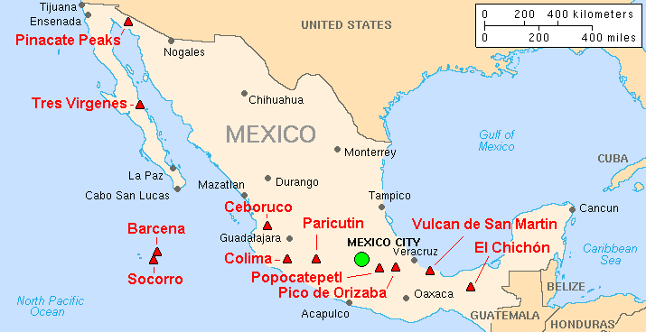
English: Map of major volcanoes of Mexico |
|||
| දිනය | ||||
| මූලාශ්රය | Archived source link; base map from CIA, 2003; volcanoes from Simkin and Siebert, 1994 | |||
| කර්තෘ | Lyn Topinka, USGS | |||
| අවසරය (මෙම ගොනුව නැවත භාවිතා කරමින්) |
|
|||
| අනෙකුත් අනුවාදයන් |
|
ගොනු ඉතිහාසය
එම අවස්ථාවෙහිදී ගොනුව පැවැති ආකාරය නැරඹීමට දිනය/වේලාව මත ක්ලික් කරන්න.
| දිනය/වේලාව | කුඩා-රූපය | මාන | පරිශීලක | පරිකථනය | |
|---|---|---|---|---|---|
| වත්මන් | 08:00, 16 පෙබරවාරි 2014 | | 715 × 368 (14 කි.බ.) | Hike395 | Crop title, logo, and credit line |
| 10:58, 19 ජනවාරි 2005 |  | 728 × 465 (18 කි.බ.) | GarciaB~commonswiki | Major Volcanoes of Mexico |
ගොනු භාවිතය
පහත දැක්වෙන පිටුව විසින් මෙම ගොනුව භාවිතා කෙරෙයි:
ගෝලීය ගොනු භාවිතය
පහත දැක්වෙන අනෙකුත් විකියන් මගින් මෙම ගොනුව භාවිතා කරයි:
- ar.wikipedia.org හි භාවිතය
- az.wikipedia.org හි භාවිතය
- bg.wikipedia.org හි භාවිතය
- bs.wikipedia.org හි භාවිතය
- ca.wikipedia.org හි භාවිතය
- cs.wikipedia.org හි භාවිතය
- de.wikipedia.org හි භාවිතය
- en.wikipedia.org හි භාවිතය
- eo.wikipedia.org හි භාවිතය
- es.wikipedia.org හි භාවිතය
- eu.wikipedia.org හි භාවිතය
- fa.wikipedia.org හි භාවිතය
- fi.wikipedia.org හි භාවිතය
- fr.wikipedia.org හි භාවිතය
- gl.wikipedia.org හි භාවිතය
- he.wikipedia.org හි භාවිතය
- hy.wikipedia.org හි භාවිතය
- id.wikipedia.org හි භාවිතය
- it.wikipedia.org හි භාවිතය
- it.wikivoyage.org හි භාවිතය
- ka.wikipedia.org හි භාවිතය
- ko.wikipedia.org හි භාවිතය
- nl.wikipedia.org හි භාවිතය
- nn.wikipedia.org හි භාවිතය
- no.wikipedia.org හි භාවිතය
- pl.wikipedia.org හි භාවිතය
- pt.wikipedia.org හි භාවිතය
- ro.wikipedia.org හි භාවිතය
- ru.wikipedia.org හි භාවිතය
මෙම ගොනුවේ තවත් ගෝලීය භාවිත බලන්න.