ගොනුව:Topography Sri Lanka.jpg

මෙම පෙරදසුනෙහි විශාලත්වය: 346 × 600 පික්සල. අනෙකුත් විභේදනයන්: 138 × 240 පික්සල | 277 × 480 පික්සල | 443 × 768 පික්සල | 591 × 1,024 පික්සල | 1,181 × 2,048 පික්සල | 3,000 × 5,200 පික්සල.
මුල් ගොනුව (3,000 × 5,200 පික්සල, ගොනු විශාලත්වය: 3.27 මෙ.බ., MIME ශෛලිය: image/jpeg)
සාරාංශය
| විස්තරය |
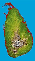
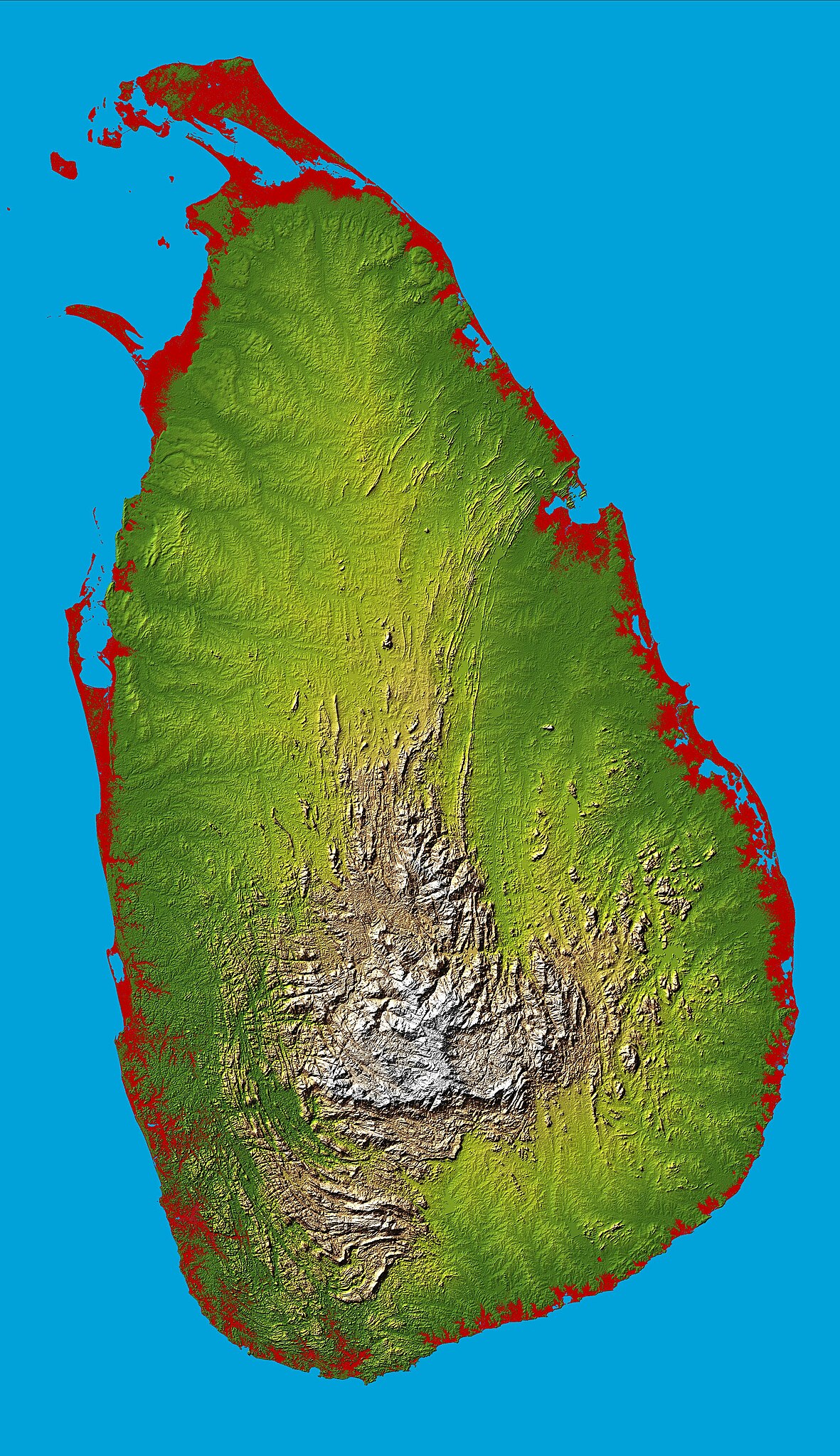
English: Topography of Sri Lanka, obtained from the Shuttle Radar Topography Mission of STS-99, aboard the Space Shuttle Endeavour. Heights below 10 meters (33 feet) above sea level have been colored red. |
| දිනය | |
| මූලාශ්රය | http://photojournal.jpl.nasa.gov/catalog/PIA06670 |
| කර්තෘ | National Aeronautics & Space Administration |
| Object location | | View this and other nearby images on: OpenStreetMap |
|---|
බලපත්රීකරණය
| This file is in the public domain in the United States because it was solely created by NASA. NASA copyright policy states that "NASA material is not protected by copyright unless noted". (See Template:PD-USGov, NASA copyright policy page or JPL Image Use Policy.) | ||
 |
Warnings:
|
ගොනු ඉතිහාසය
එම අවස්ථාවෙහිදී ගොනුව පැවැති ආකාරය නැරඹීමට දිනය/වේලාව මත ක්ලික් කරන්න.
| දිනය/වේලාව | කුඩා-රූපය | මාන | පරිශීලක | පරිකථනය | |
|---|---|---|---|---|---|
| වත්මන් | 17:43, 27 මාර්තු 2005 | | 3,000 × 5,200 (3.27 මෙ.බ.) | FEXX | {{PD-USGov-NASA}} |
ගොනු භාවිතය
පහත දැක්වෙන පිටු 2 ක් විසින් මෙම ගොනුව භාවිතා කෙරෙයි:
ගෝලීය ගොනු භාවිතය
පහත දැක්වෙන අනෙකුත් විකියන් මගින් මෙම ගොනුව භාවිතා කරයි:
- af.wikipedia.org හි භාවිතය
- ar.wikipedia.org හි භාවිතය
- arz.wikipedia.org හි භාවිතය
- ast.wikipedia.org හි භාවිතය
- az.wikipedia.org හි භාවිතය
- bcl.wikipedia.org හි භාවිතය
- be.wikipedia.org හි භාවිතය
- bg.wikipedia.org හි භාවිතය
- bg.wiktionary.org හි භාවිතය
- bn.wikipedia.org හි භාවිතය
- ca.wikipedia.org හි භාවිතය
- ceb.wikipedia.org හි භාවිතය
- de.wikipedia.org හි භාවිතය
- de.wikivoyage.org හි භාවිතය
- diq.wikipedia.org හි භාවිතය
- el.wikipedia.org හි භාවිතය
- en.wikipedia.org හි භාවිතය
- Sri Lanka
- Geography of Sri Lanka
- Portal:Sri Lanka
- User:Trengarasu
- User:Deavenger
- Outline of Sri Lanka
- User:RitigalaJayasena/UserBoxes/EquitySriLanka
- User:ProudIrishAspie
- User:Djodjo666
- User:Blackknight12/sandbox
- User:DaisyGeekyTransGirl
- Wikipedia:Graphics Lab/Map workshop/Archive/Dec 2015
- User:JFoog
- User:Okiloma
- Wikipedia:Userboxes/Politics by country/Sri Lanka
- en.wikiversity.org හි භාවිතය
- eo.wikipedia.org හි භාවිතය
- es.wikipedia.org හි භාවිතය
- et.wikipedia.org හි භාවිතය
- fa.wikipedia.org හි භාවිතය
- fi.wikipedia.org හි භාවිතය
- fr.wikipedia.org හි භාවිතය
මෙම ගොනුවේ තවත් ගෝලීය භාවිත බලන්න.