ගොනුව:NZ Marlborough Sounds relief location map.svg

Size of this PNG preview of this SVG file: 452 × 599 පික්සල. අනෙකුත් විභේදනයන්: 181 × 240 පික්සල | 362 × 480 පික්සල | 579 × 768 පික්සල | 773 × 1,024 පික්සල | 1,546 × 2,048 පික්සල | 2,600 × 3,445 පික්සල.
මුල් ගොනුව (SVG ගොනුව, නාමමාත්රිකව 2,600 × 3,445 පික්සල්, ගොනු විශාලත්වය: 3.87 මෙ.බ.)
සාරාංශය
| විස්තරය |
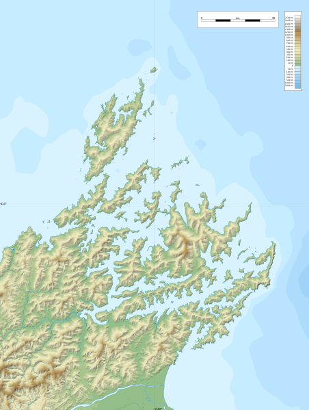
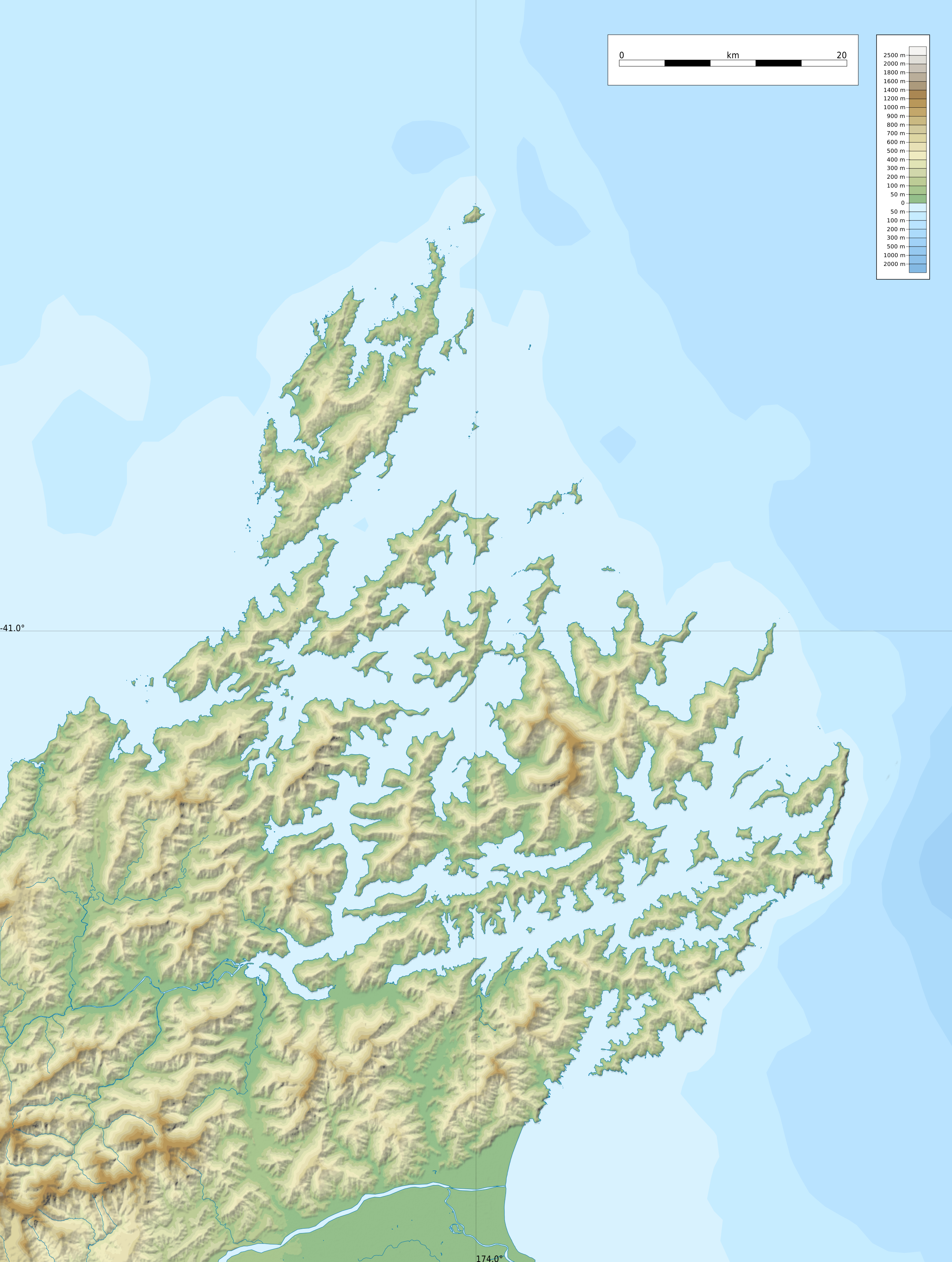
English: Relief location map of Marlborough Sounds, New Zealand
Geographic limits of the map:
|
| දිනය | |
| මූලාශ්රය |
ස්වයං නිර්මාණයකි
|
| කර්තෘ | ikonact |
බලපත්රීකරණය
| This work contains information from OpenStreetMap, which is made available under the Open Database License (ODbL).
The ODbL does not require any particular license for maps produced from ODbL data. Prior to 1 August 2020, map tiles produced by the OpenStreetMap Foundation were licensed under the CC-BY-SA-2.0 license. Maps produced by other people may be subject to other licences. |
මෙම කෘතියෙහි හිමිකම් අයිතීන් දරන්නා වන මම,පහත වරපත යටතේ එය ප්රකාශයට පත් කරමි:
This file is licensed under the Creative Commons Attribution-Share Alike 4.0 International license.
- ඔබ නිදහස්:
- බෙදාහදා ගැනීමට – කාර්යය පිටපත් කිරීමට,බෙදා හැරීමට සහ සම්ප්රේෂණය කිරීමට
- නැවත සංකලනය කිරීමට – කාර්යයට අනුවර්තනය වීමට
- පහත කොන්දේසිවලට යටත්ව:
- attribution – වරපත වෙත බැඳියක්ද සපයමින් ඔබ විසින් සුදුසු කර්තෘභාරය ප්රදානය කල යුතු අතර, කිසියම් වෙනස්වීම් සිදුකලේ නම් එයද සඳහන් කල යුතු වෙයි. ඕනෑම සුදුසු ආකාරයට මෙය ඔබ විසින් සිදුකල හැකි මුත්, වරපත්දායකයා විසින් ඔබ හෝ ඔබගේ භාවිතය හෝ පිටසන් කරන බවට ඇඟවෙන ලෙසින් එය සිදු නොකල යුතු වෙයි.
- share alike – මෙම විෂය කාරණා භාවිතා කොට නැවත සංකලනය, ප්රතියෝජනය හෝ වැඩිදියුණුව කලේ නම්, ඉන්පසු ඔබගේ දායකත්වය ඔබ විසින් බෙදාහැරිය යුත්තේ මුල් වරපත හා සමාන හෝ සංගතික හෝ වරපතක් භාවිතා කරමිනි.
ගොනු ඉතිහාසය
එම අවස්ථාවෙහිදී ගොනුව පැවැති ආකාරය නැරඹීමට දිනය/වේලාව මත ක්ලික් කරන්න.
| දිනය/වේලාව | කුඩා-රූපය | මාන | පරිශීලක | පරිකථනය | |
|---|---|---|---|---|---|
| වත්මන් | 22:55, 8 පෙබරවාරි 2022 | | 2,600 × 3,445 (3.87 මෙ.බ.) | Ikonact | == {{int:filedesc}} == {{Information |description={{en|1=Relief location map of {{W|Marlborough Sounds}}, {{W|New Zealand}} Geographic limits of the map: * N: 40.5° S * S: 41.5° S * W: 173.5° E * E: 174.0° E}} |date=2022-02-08 |source={{own}} *Relief and bathymetry: Public domain SRTM3 and ETOPO1 *Coast: [https://data.linz.govt.nz/layer/105085-nz-coastline-mean-high-water/ Land Information New Zealand] © Creative Commons Attribution 4.0 International *Water bodies and rivers: © OpenStreetMap... |
ගොනු භාවිතය
පහත දැක්වෙන පිටු 2 ක් විසින් මෙම ගොනුව භාවිතා කෙරෙයි:
ගෝලීය ගොනු භාවිතය
පහත දැක්වෙන අනෙකුත් විකියන් මගින් මෙම ගොනුව භාවිතා කරයි:
- en.wikipedia.org හි භාවිතය
- Tory Channel
- Pelorus Sound
- Queen Charlotte Sound / Tōtaranui
- Cloudy Bay
- Maud Island
- Cape Jackson, New Zealand
- Port Underwood
- Linkwater
- Blumine Island
- Meretoto / Ship Cove
- Whatamangō Bay
- Lochmara Bay
- Module:Location map/data/New Zealand Marlborough Sounds
- Module:Location map/data/New Zealand Marlborough Sounds/doc
- Wikipedia:New Zealand Wikipedians' notice board/Archive 31
- Resolution Bay
- Endeavour Inlet
- fr.wikipedia.org හි භාවිතය
- Île d'Urville (Nouvelle-Zélande)
- The Brothers (Nouvelle-Zélande)
- Île de Maud
- Marlborough Sounds
- Phare de l'île Stephens
- Phare de Brothers Island
- Île Stephens
- French Pass
- Île Blumine
- Baie de Pelorus
- Baie de Tōtaranui
- Baie de Kenepuru
- Mont Stokes
- Île Arapaoa
- Canal de Tory
- Baie de Tennyson
- Te Whanganui
- Croisilles Harbour
- Baie de l'Amirauté (Nouvelle-Zélande)
- Modèle:Géolocalisation/Marlborough Sounds
- Modèle:Géolocalisation/Marlborough Sounds/Documentation
- Île Matapara
- Cap Soucis
- Île Motuara
- Long Island (Marlborough)
- Baie Anakoha
- Île Forsyth
- Îles Chetwode
- Port Gore
- uz.wikipedia.org හි භාවිතය