ගොනුව:Mashonaland East districts.png
මෙම පෙරදසුනෙහි විශාලත්වය: 776 × 600 පික්සල. අනෙකුත් විභේදනයන්: 311 × 240 පික්සල | 621 × 480 පික්සල | 994 × 768 පික්සල | 1,056 × 816 පික්සල.
මුල් ගොනුව (1,056 × 816 පික්සල, ගොනු විශාලත්වය: 39 කි.බ., MIME ශෛලිය: image/png)
සාරාංශය
| විස්තරය |
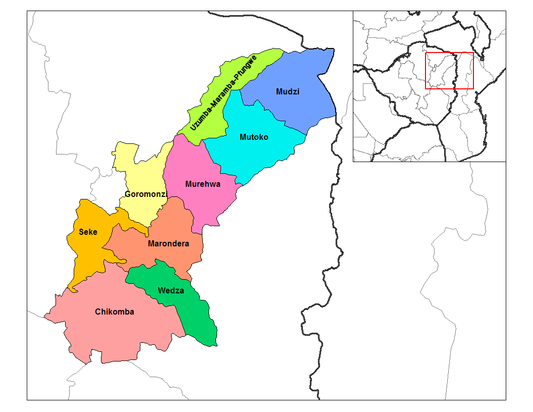
English: Map of the districts of Mashonaland East province of Zimbabwe. |
| දිනය | |
| මූලාශ්රය |
ස්වයං නිර්මාණයකි (Rarelibra) using MapInfo Professional v8.5 and various mapping resources. Transferred from en.wikipedia |
| කර්තෘ | Rarelibra at en.wikipedia |
බලපත්රීකරණය
| මෙම කාර්යය එහි කර්තෘ, Rarelibra at ඉංග්රීසි විකිපීඩියා, විසින් public domain වෙත නිදහස් කර ඇත. එය ලෝක ව්යාප්තව අදාළ වේ. සමහර රටවල මෙය අනීතික විය හැකිය. එසේ වුවහොත්; නීතියෙන් යම් කොන්දේසියක් පනවා ඇති නම් හැරෙන්නට කිසිදු කොන්දේසියකින් තොරව ඕනෑම ප්රයෝජනයක් සඳහා මෙම කාර්යය භාවිතා කිරීමේ අයිතිය Rarelibra විසින් ලබා දෙයි. |
ප්රකෘති පැටවුම් ලොගය
The original description page was here. All following user names refer to en.wikipedia.
- 2006-09-28 18:29 Rarelibra 1056×816× (34182 bytes) Map of the districts of Mashonaland East province of Angola. Created by ~~~~ for public domain use, using MapInfo Professional v8.5 and various mapping resources.
ගොනු ඉතිහාසය
එම අවස්ථාවෙහිදී ගොනුව පැවැති ආකාරය නැරඹීමට දිනය/වේලාව මත ක්ලික් කරන්න.
| දිනය/වේලාව | කුඩා-රූපය | මාන | පරිශීලක | පරිකථනය | |
|---|---|---|---|---|---|
| වත්මන් | 20:15, 22 අප්රේල් 2014 | | 1,056 × 816 (39 කි.බ.) | Maproom | Relabelled the northern of the two "Murehwa" districts as "Uzumba-Maramba-Pfungwe", as requested at https://en.wikipedia.org/wiki/Wikipedia:Graphics_Lab/Map_workshop on April 22nd, 2014. |
| 13:36, 10 ජනවාරි 2011 |  | 1,056 × 816 (33 කි.බ.) | Klik9 | {{Information |Description=Map of the districts of Mashonaland East province of Zimbabwe |Source=Originally from [http://en.wikipedia.org en.wikipedia]; description page is (was) here |Date=2006 |Author=[[Rareli |
ගොනු භාවිතය
පහත දැක්වෙන පිටුව විසින් මෙම ගොනුව භාවිතා කෙරෙයි:
ගෝලීය ගොනු භාවිතය
පහත දැක්වෙන අනෙකුත් විකියන් මගින් මෙම ගොනුව භාවිතා කරයි:
- ca.wikipedia.org හි භාවිතය
- de.wikipedia.org හි භාවිතය
- en.wikipedia.org හි භාවිතය
- es.wikipedia.org හි භාවිතය
- frr.wikipedia.org හි භාවිතය
- it.wikipedia.org හි භාවිතය
- ja.wikipedia.org හි භාවිතය
- ka.wikipedia.org හි භාවිතය
- lt.wikipedia.org හි භාවිතය
- mrj.wikipedia.org හි භාවිතය
- nl.wikipedia.org හි භාවිතය
- pl.wikipedia.org හි භාවිතය
- pt.wikipedia.org හි භාවිතය
- ro.wikipedia.org හි භාවිතය
- ru.wikipedia.org හි භාවිතය
- sn.wikipedia.org හි භාවිතය
- tr.wikipedia.org හි භාවිතය
- uk.wikipedia.org හි භාවිතය
- zu.wikipedia.org හි භාවිතය