ගොනුව:Mapa Sao Paulo Ferrovias.svg

Size of this PNG preview of this SVG file: 800 × 500 පික්සල. අනෙකුත් විභේදනයන්: 320 × 200 පික්සල | 640 × 400 පික්සල | 1,024 × 640 පික්සල | 1,280 × 800 පික්සල | 2,560 × 1,601 පික්සල | 1,017 × 636 පික්සල.
මුල් ගොනුව (SVG ගොනුව, නාමමාත්රිකව 1,017 × 636 පික්සල්, ගොනු විශාලත්වය: 43 කි.බ.)
| විස්තරය |
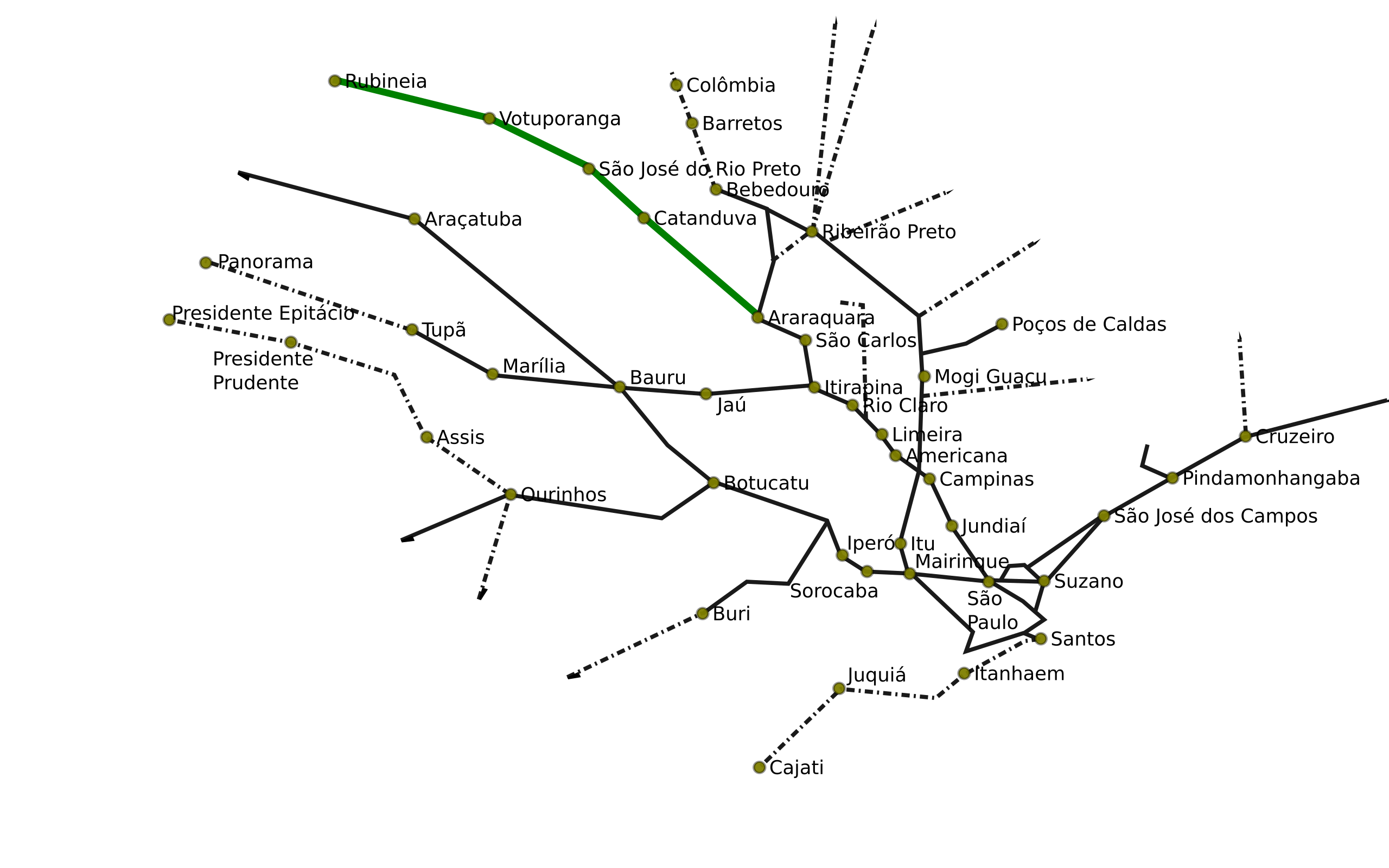
Português: Mapa de Ferrovias do Estado de São Paulo
English: Map of the railways of the brazilian State of São Paulo |
|||
| දිනය | (UTC) | |||
| මූලාශ්රය | ||||
| කර්තෘ |
|
|||
| අනෙකුත් අනුවාදයන් |
Derivative works of this file: Mapa Cajati Santos.png
|
|||
| SVG genesis |
|


I, මෙම කාර්යයේ ප්රකාශන අයිතිය දරන්නා,පහත බලපත්රය යටතේ එය ප්රකාශයට පත් කරනු ලබයි:
මෙම ගොනුව නිර්මාණශීලී පොදුවූවන් Attribution 2.5 Generic බලපත්රය යටතේ අවසර ලබා ඇත.
- ඔබ නිදහස්:
- බෙදාහදා ගැනීමට – කාර්යය පිටපත් කිරීමට,බෙදා හැරීමට සහ සම්ප්රේෂණය කිරීමට
- නැවත සංකලනය කිරීමට – කාර්යයට අනුවර්තනය වීමට
- පහත කොන්දේසිවලට යටත්ව:
- attribution – වරපත වෙත බැඳියක්ද සපයමින් ඔබ විසින් සුදුසු කර්තෘභාරය ප්රදානය කල යුතු අතර, කිසියම් වෙනස්වීම් සිදුකලේ නම් එයද සඳහන් කල යුතු වෙයි. ඕනෑම සුදුසු ආකාරයට මෙය ඔබ විසින් සිදුකල හැකි මුත්, වරපත්දායකයා විසින් ඔබ හෝ ඔබගේ භාවිතය හෝ පිටසන් කරන බවට ඇඟවෙන ලෙසින් එය සිදු නොකල යුතු වෙයි.

|
Free Software Foundation විසින් ප්රකාශිත GNU Free Documentation License බලපත්රයෙහි 1.2 හෝ ඊට අලුත් පිටපත්වල කොන්දේසිවලට යටත්ව මෙම ගොනුව පිටපත් කෙරුමට, නැවත බෙදාහාරුමට සහ/හෝ වෙනස් කෙරුමට අවසර දී ඇත; ඒ වෙනස් අංශ නොමැතිව, මුල් පිටු පෙළ නොමැතිව, පසු පිටු පෙළ නොමැතිවය. බලපත්රයේ පිටපතක් GNU Free Documentation License නම් අංශයේ දැක්වේ. |
| මෙම ගොනුව ක්රියේටිව් කොමන්ස් Attribution-Share Alike 3.0 Unported වරපත යටතේ අවසර ලබා ඇත. | ||
| ||
| GFDL බලපත්ර යාවත්කාල කෙරුමහි කොටසක් ලෙස මෙම ගොනුවට බලපත්ර ටැගය එක් කෙරිනි. |
ඔබට අභිමත වරපත තෝරාගත හැක.
ප්රකෘති පැටවුම් ලොගය
This image is a derivative work of the following images:
- File:SaoPaulo_MesoMicroMunicip.svg licensed with Cc-by-2.5, GFDL
- 2006-08-30T20:50:02Z Raphael.lorenzeto 1020x638 (1123987 Bytes) trocando por versão com geocódigos
- 2006-06-27T16:05:41Z Giro720 1024x691 (1097141 Bytes) Revertido para versão mais nova
- 2006-06-27T16:04:32Z Giro720 1006x684 (1442727 Bytes) Revertido para versão mais nova
- 2006-06-11T20:55:57Z Raphael.lorenzeto 1024x691 (1097141 Bytes) '
- 2006-05-02T02:12:11Z Raphael.lorenzeto 1006x684 (1442727 Bytes) {{User:Raphael.lorenzeto/DerivativeMaps}} {{Information| |Description=Map of São Paulo state |Source=own work |Date=April, 20 2006 |Author=Raphael Lorenzeto de Abreu |Permission={{self2|GFDL|cc-by-2.5}} |other_versions= }} [
Uploaded with derivativeFX
ගොනු ඉතිහාසය
එම අවස්ථාවෙහිදී ගොනුව පැවැති ආකාරය නැරඹීමට දිනය/වේලාව මත ක්ලික් කරන්න.
| දිනය/වේලාව | කුඩා-රූපය | මාන | පරිශීලක | පරිකථනය | |
|---|---|---|---|---|---|
| වත්මන් | 17:02, 1 ජූලි 2010 | | 1,017 × 636 (43 කි.බ.) | DieBucheBot | Trying to fix SVG using scour |
| 03:19, 1 ජූනි 2009 |  | 1,017 × 636 (70 කි.බ.) | Sekelsenmat | {{Information |Description=Mapa de Ferrovias do Estado de São Paulo |Source=*File:SaoPaulo_MesoMicroMunicip.svg |Date=2009-06-01 04:19 (UTC) |Author=*File:SaoPaulo_MesoMicroMunicip.svg: Raphael Lorenzeto de Abreu *derivative work: ~~~ |Permis |
ගොනු භාවිතය
මෙම ගොනුව භාවිතා කරන නිසිදු පිටුවක් නොමැත.