ගොනුව:Map of North Dakota NA.png
මෙම පෙරදසුනෙහි විශාලත්වය: 776 × 600 පික්සල. අනෙකුත් විභේදනයන්: 311 × 240 පික්සල | 621 × 480 පික්සල | 994 × 768 පික්සල | 1,280 × 989 පික්සල | 2,122 × 1,640 පික්සල.
මුල් ගොනුව (2,122 × 1,640 පික්සල, ගොනු විශාලත්වය: 1.75 මෙ.බ., MIME ශෛලිය: image/png)
සාරාංශය
| විස්තරය |
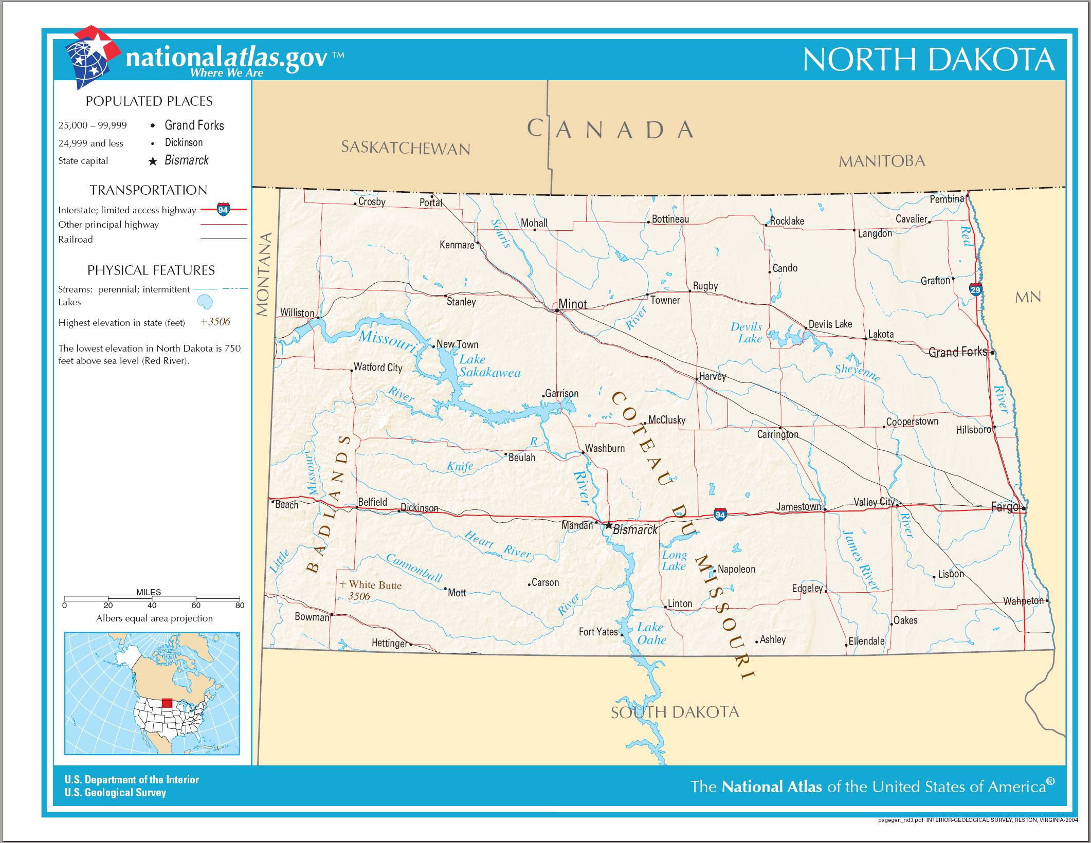
English: Map of North Dakota. |
| දිනය | |
| මූලාශ්රය | National Atlas |
| කර්තෘ |
බලපත්රීකරණය
This map was obtained from an edition of the National Atlas of the United States. Like almost all works of the U.S. federal government, works from the National Atlas are in the public domain in the United States.
Online access: NationalAtlas.gov | 1970 print edition: Library of Congress, Perry-Castañeda Library
|
ගොනු ඉතිහාසය
එම අවස්ථාවෙහිදී ගොනුව පැවැති ආකාරය නැරඹීමට දිනය/වේලාව මත ක්ලික් කරන්න.
| දිනය/වේලාව | කුඩා-රූපය | මාන | පරිශීලක | පරිකථනය | |
|---|---|---|---|---|---|
| වත්මන් | 21:40, 14 අගෝස්තු 2006 | | 2,122 × 1,640 (1.75 මෙ.බ.) | Huebi~commonswiki | {{Information| |Description=Map of North Dakota |Source=[http://www.nationalatlas.gov National Atlas] }} Category:Maps of the United States Category:Maps of North Dakota {{PD-USGov-Atlas}} |
ගොනු භාවිතය
පහත දැක්වෙන පිටු 3 ක් විසින් මෙම ගොනුව භාවිතා කෙරෙයි:
ගෝලීය ගොනු භාවිතය
පහත දැක්වෙන අනෙකුත් විකියන් මගින් මෙම ගොනුව භාවිතා කරයි:
- als.wikipedia.org හි භාවිතය
- ca.wikipedia.org හි භාවිතය
- de.wikipedia.org හි භාවිතය
- en.wikipedia.org හි භාවිතය
- hu.wikipedia.org හි භාවිතය
- ilo.wikipedia.org හි භාවිතය
- incubator.wikimedia.org හි භාවිතය
- it.wikipedia.org හි භාවිතය
- kn.wikipedia.org හි භාවිතය
- lt.wikipedia.org හි භාවිතය
- ro.wikipedia.org හි භාවිතය
- Dakota de Nord
- Categorie:Cioturi stat North Dakota, SUA
- Northwood, Dakota de Nord
- Prefix telefonic 701 (Statele Unite ale Americii)
- Categorie:Teritoriul Dakota
- Listă de oameni din statul Dakota de Nord
- Listă de comitate din statul Dakota de Nord
- Listă de orașe din statul Dakota de Nord
- Comitatul Adams, Dakota de Nord
- Categorie:Zone micropolitane din North Dakota
- Categorie:Baraje din North Dakota
- Categorie:Guvernatori ai statului North Dakota
- Categorie:Istoria statului Dakota de Nord
- Categorie:Dakota de Nord
- Categorie:Oameni din Dakota de Nord după comitat
- Categorie:Clădiri și structuri din statul Dakota de Nord
- Amidon, Dakota de Nord
- Watford City, Dakota de Nord
- Categorie:Formate Dakota de Nord
- Categorie:Localități din Dakota de Nord
- Categorie:Zone metropolitane din Dakota de Nord
- Categorie:Localități din Dakota de Nord după comitat
- Categorie:Comitatul Grand Forks, Dakota de Nord
- Categorie:Comitatul LaMoure, Dakota de Nord
- Mott, Dakota de Nord
- Categorie:Localități din comitatul Hettinger, Dakota de Nord
- Categorie:Geografia comitatului Hettinger, Dakota de Nord
- Categorie:Localități din comitatul Eddy, Dakota de Nord
- Categorie:Comitatul Slope, Dakota de Nord
- Categorie:Membri ai legislaturii statului Dakota de Nord
මෙම ගොනුවේ තවත් ගෝලීය භාවිත බලන්න.