ගොනුව:Lochaber UK relief location map.jpg

මෙම පෙරදසුනෙහි විශාලත්වය: 800 × 501 පික්සල. අනෙකුත් විභේදනයන්: 320 × 200 පික්සල | 640 × 401 පික්සල | 1,024 × 641 පික්සල | 1,280 × 802 පික්සල | 2,001 × 1,253 පික්සල.
මුල් ගොනුව (2,001 × 1,253 පික්සල, ගොනු විශාලත්වය: 532 කි.බ., MIME ශෛලිය: image/jpeg)
| විස්තරය |
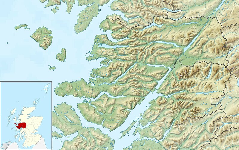
Relief map of Lochaber, UK. Equirectangular map projection on WGS 84 datum, with N/S stretched 180% Geographic limits:
|
| දිනය | |
| මූලාශ්රය |
|
| කර්තෘ | Nilfanion, created using Ordnance Survey data |
| අවසරය (මෙම ගොනුව නැවත භාවිතා කරමින්) |
මෙම ගොනුව ක්රියේටිව් කොමන්ස් Attribution-Share Alike 3.0 Unported වරපත යටතේ අවසර ලබා ඇත. Attribution: Contains Ordnance Survey data © Crown copyright and database right
|
| අනෙකුත් අනුවාදයන් | File:Lochaber UK blank map.svg - Blank map |
ගොනු ඉතිහාසය
එම අවස්ථාවෙහිදී ගොනුව පැවැති ආකාරය නැරඹීමට දිනය/වේලාව මත ක්ලික් කරන්න.
| දිනය/වේලාව | කුඩා-රූපය | මාන | පරිශීලක | පරිකථනය | |
|---|---|---|---|---|---|
| වත්මන් | 00:29, 17 දෙසැම්බර් 2011 | | 2,001 × 1,253 (532 කි.බ.) | Nilfanion | {{Information |Description=Relief map of Lochaber, UK. Equirectangular map projection on WGS 84 datum, with N/S stretched 180% Geographic limits: *West: 6.75W *East: 4.45W *North: 57.20N *South: 56.40N |Source=[[w:Ordnance Survey|Ordnanc |
ගොනු භාවිතය
පහත දැක්වෙන පිටු 2 ක් විසින් මෙම ගොනුව භාවිතා කෙරෙයි:
ගෝලීය ගොනු භාවිතය
පහත දැක්වෙන අනෙකුත් විකියන් මගින් මෙම ගොනුව භාවිතා කරයි:
- ar.wikipedia.org හි භාවිතය
- ceb.wikipedia.org හි භාවිතය
- cs.wikipedia.org හි භාවිතය
- en.wikipedia.org හි භාවිතය
- Rùm
- Canna, Scotland
- Muck, Scotland
- Eigg
- Sanday, Inner Hebrides
- Loch Morar
- Eilean Chathastail
- Castle Tioram
- Loch Ossian
- An Gearanach
- Glen Roy
- Eilean Shona
- Ardtornish
- Loch Sunart
- River Garry, Inverness-shire
- Module:Location map/data/Scotland Lochaber/doc
- Kentra Bay
- Ariundle Oakwood
- Loch Bà (Rannoch Moor)
- Loch Achtriochtan
- Loch Buidhe (Rannoch Moor)
- Glenborrodale Bay
- Glenmore Bay
- Loch Arienas
- River Spean
- River Lochy
- Ardtornish Bay
- Module:Location map/data/Scotland Lochaber
- Sandaig Bay
- Lochan na Stainge
- Inverie Bay
- Loch Beoraid
- Loch an Nostarie
- Loch a' Ghille Ghobaich
- Loch na Bairness
- fr.wikipedia.org හි භාවිතය
- ja.wikipedia.org හි භාවිතය
- kn.wikipedia.org හි භාවිතය
- pl.wikipedia.org හි භාවිතය
- sco.wikipedia.org හි භාවිතය
- tr.wikipedia.org හි භාවිතය
මෙම ගොනුවේ තවත් ගෝලීය භාවිත බලන්න.