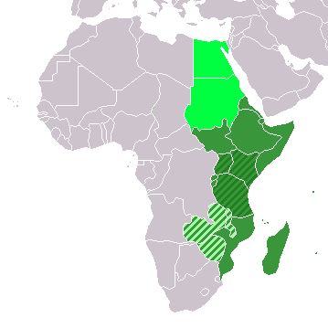
ගොනුව:LocationEasternAfrica.png
LocationEasternAfrica.png (359 × 359 පික්සල, ගොනු විශාලත්වය: 8 කි.බ., MIME ශෛලිය: image/png)
ගොනු ඉතිහාසය
එම අවස්ථාවෙහිදී ගොනුව පැවැති ආකාරය නැරඹීමට දිනය/වේලාව මත ක්ලික් කරන්න.
| දිනය/වේලාව | කුඩා-රූපය | මාන | පරිශීලක | පරිකථනය | |
|---|---|---|---|---|---|
| වත්මන් | 13:16, 11 නොවැම්බර් 2022 |  | 359 × 359 (8 කි.බ.) | ColorfulSmoke | . |
| 11:54, 11 නොවැම්බර් 2022 |  | 360 × 359 (8 කි.බ.) | ColorfulSmoke | ||
| 17:01, 17 මාර්තු 2018 |  | 360 × 392 (11 කි.බ.) | Maphobbyist | Upload | |
| 00:30, 20 දෙසැම්බර් 2012 |  | 360 × 392 (8 කි.බ.) | Spacepotato | Recolor to reflect placement of South Sudan in Eastern Africa according to the UN classification scheme, http://unstats.un.org/unsd/methods/m49/m49regin.htm . | |
| 17:01, 9 ජූලි 2011 |  | 360 × 392 (14 කි.බ.) | Maphobbyist | South Sudan has become independent on July 9, 2011. Sudan and South Sudan are shown with the new international border between them. | |
| 08:15, 11 දෙසැම්බර් 2007 |  | 360 × 392 (14 කි.බ.) | Hoshie | added Cabinda (Angola) and Montenegro. | |
| 15:56, 2 අප්රේල් 2006 |  | 360 × 392 (9 කි.බ.) | E Pluribus Anthony~commonswiki | Reverted to earlier revision | |
| 05:47, 1 අප්රේල් 2006 |  | 360 × 392 (14 කි.බ.) | Aris Katsaris | No need to include regional organizations -- it makes the map much harder to read for no relevant purpose. The map should be clear in its purpose. | |
| 12:37, 5 පෙබරවාරි 2006 |  | 360 × 392 (9 කි.බ.) | E Pluribus Anthony~commonswiki | Map: Eastern Africa (location) |
ගොනු භාවිතය
පහත දැක්වෙන පිටු 3 ක් විසින් මෙම ගොනුව භාවිතා කෙරෙයි:
ගෝලීය ගොනු භාවිතය
පහත දැක්වෙන අනෙකුත් විකියන් මගින් මෙම ගොනුව භාවිතා කරයි:
- ace.wikipedia.org හි භාවිතය
- af.wikipedia.org හි භාවිතය
- als.wikipedia.org හි භාවිතය
- am.wikipedia.org හි භාවිතය
- ar.wikipedia.org හි භාවිතය
- ليبيا
- جيبوتي
- موريتانيا
- تونس
- السودان
- الصحراء الغربية
- أنغولا
- أوغندا
- إسبانيا
- تشاد
- النيجر
- مالي
- السنغال
- غامبيا
- غينيا بيساو
- غينيا
- سيراليون
- ليبيريا
- غانا
- توغو
- بنين
- بوركينا فاسو
- الصومال
- كينيا
- تنزانيا
- الغابون
- زامبيا
- موزمبيق
- زيمبابوي
- البرتغال
- الكاميرون
- جمهورية الكونغو الديمقراطية
- بوتسوانا
- جنوب إفريقيا
- جمهورية إفريقيا الوسطى
- جمهورية الكونغو
- سيشل
- ناميبيا
- مدغشقر
- ليسوتو
- موريشيوس
- نهر النيل
මෙම ගොනුවේ තවත් ගෝලීය භාවිත බලන්න.

