ගොනුව:Grenada location map.svg

Size of this PNG preview of this SVG file: 634 × 599 පික්සල. අනෙකුත් විභේදනයන්: 254 × 240 පික්සල | 508 × 480 පික්සල | 813 × 768 පික්සල | 1,084 × 1,024 පික්සල | 2,167 × 2,048 පික්සල | 1,435 × 1,356 පික්සල.
මුල් ගොනුව (SVG ගොනුව, නාමමාත්රිකව 1,435 × 1,356 පික්සල්, ගොනු විශාලත්වය: 134 කි.බ.)
සාරාංශය
| විස්තරය |
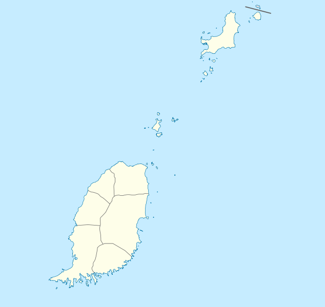
Deutsch: Positionskarte von Grenada
Geographische Begrenzung der Karte:
English: Location map of Grenada
Geographic limits of the map:
|
||||||||||||
| දිනය | |||||||||||||
| මූලාශ්රය | ස්වයං නිර්මාණයකි | ||||||||||||
| කර්තෘ | NordNordWest | ||||||||||||
| අවසරය (මෙම ගොනුව නැවත භාවිතා කරමින්) |
|

|
This map has been made or improved in the German Kartenwerkstatt (Map Lab). You can propose maps to improve as well.
|
ගොනු ඉතිහාසය
එම අවස්ථාවෙහිදී ගොනුව පැවැති ආකාරය නැරඹීමට දිනය/වේලාව මත ක්ලික් කරන්න.
| දිනය/වේලාව | කුඩා-රූපය | මාන | පරිශීලක | පරිකථනය | |
|---|---|---|---|---|---|
| වත්මන් | 19:56, 18 දෙසැම්බර් 2009 | | 1,435 × 1,356 (134 කි.බ.) | NordNordWest | == {{int:filedesc}} == {{Information |Description= {{de|Positionskarte von Grenada}} Geographische Begrenzung der Karte: * N: 12.55° N * S: 11.95° N * W: 61.9° W * O: 61.25° W {{en|Location map of Grenada}} Geographic l |
ගොනු භාවිතය
පහත දැක්වෙන පිටු 2 ක් විසින් මෙම ගොනුව භාවිතා කෙරෙයි:
ගෝලීය ගොනු භාවිතය
පහත දැක්වෙන අනෙකුත් විකියන් මගින් මෙම ගොනුව භාවිතා කරයි:
- af.wikipedia.org හි භාවිතය
- an.wikipedia.org හි භාවිතය
- ar.wikipedia.org හි භාවිතය
- ast.wikipedia.org හි භාවිතය
- ba.wikipedia.org හි භාවිතය
- be-tarask.wikipedia.org හි භාවිතය
- be.wikipedia.org හි භාවිතය
- bg.wikipedia.org හි භාවිතය
- bn.wikipedia.org හි භාවිතය
- bs.wikipedia.org හි භාවිතය
- ceb.wikipedia.org හි භාවිතය
- Plantilya:Location map Grenada
- The Sisters
- Sandy Island
- Sandy Islet
- Saint John
- Saint George
- Redonda
- Green Island
- Green Islet
- Goat Point
- Bird Island
- Bird Islet
- North Point
- Victoria
- Saint George’s Bay
- Rose Rock
- Black Rock
- Long Point
- Sugar Loaf
- Hog Island
- Southwest Point
- Sister Rocks
- Gun Point
- Flamingo Bay
- Ross Point
- Bird
- White Island
මෙම ගොනුවේ තවත් ගෝලීය භාවිත බලන්න.