ගොනුව:Great Basin map.gif

මෙම පෙරදසුනෙහි විශාලත්වය: 537 × 600 පික්සල. අනෙකුත් විභේදනයන්: 215 × 240 පික්සල | 430 × 480 පික්සල | 687 × 768 පික්සල | 1,074 × 1,200 පික්සල.
මුල් ගොනුව (1,074 × 1,200 පික්සල, ගොනු විශාලත්වය: 342 කි.බ., MIME ශෛලිය: image/gif, 0.1තත්)
සාරාංශය
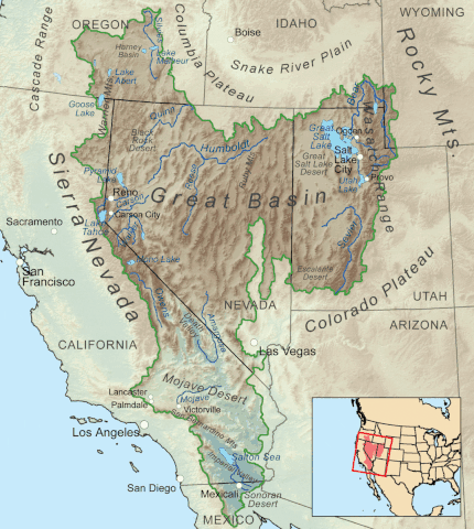
| විස්තරය | Map showing the Great Basin drainage basin as defined hydrologically. |
| දිනය | (UTC) |
| මූලාශ්රය |
This file was derived from: Greatbasinmap.png:  |
| කර්තෘ |
|
බලපත්රීකරණය
මෙම කෘතියෙහි හිමිකම් අයිතීන් දරන්නා වන Kmusser at විකිමීඩියා කොමන්ස් නමැති මම, පහත වරපත යටතේ එය ප්රකාශයට පත් කරමි:
මෙම ගොනුව ක්රියේටිව් කොමන්ස් Attribution-Share Alike 3.0 Unported වරපත යටතේ අවසර ලබා ඇත.
Attribution: Kmusser at විකිමීඩියා කොමන්ස්
- ඔබ නිදහස්:
- බෙදාහදා ගැනීමට – කාර්යය පිටපත් කිරීමට,බෙදා හැරීමට සහ සම්ප්රේෂණය කිරීමට
- නැවත සංකලනය කිරීමට – කාර්යයට අනුවර්තනය වීමට
- පහත කොන්දේසිවලට යටත්ව:
- attribution – වරපත වෙත බැඳියක්ද සපයමින් ඔබ විසින් සුදුසු කර්තෘභාරය ප්රදානය කල යුතු අතර, කිසියම් වෙනස්වීම් සිදුකලේ නම් එයද සඳහන් කල යුතු වෙයි. ඕනෑම සුදුසු ආකාරයට මෙය ඔබ විසින් සිදුකල හැකි මුත්, වරපත්දායකයා විසින් ඔබ හෝ ඔබගේ භාවිතය හෝ පිටසන් කරන බවට ඇඟවෙන ලෙසින් එය සිදු නොකල යුතු වෙයි.
- share alike – මෙම විෂය කාරණා භාවිතා කොට නැවත සංකලනය, ප්රතියෝජනය හෝ වැඩිදියුණුව කලේ නම්, ඉන්පසු ඔබගේ දායකත්වය ඔබ විසින් බෙදාහැරිය යුත්තේ මුල් වරපත හා සමාන හෝ සංගතික හෝ වරපතක් භාවිතා කරමිනි.
ප්රකෘති පැටවුම් ලොගය
This image is a derivative work of the following images:
- File:Greatbasinmap.png licensed with Cc-by-sa-3.0
- 2020-09-04T22:25:15Z Nwbeeson 1500x1676 (7565343 Bytes) Added boundary map. Second attempt to upload the image.
- 2020-09-04T22:21:06Z Nwbeeson 1500x1676 (7564895 Bytes) Added boundary line.
- 2010-12-11T16:58:55Z Kmusser 1500x1676 (3820728 Bytes) Added Goose Lake
- 2010-11-17T20:37:07Z Kmusser 1500x1676 (3382394 Bytes) == Summary == {{Information |Description=Map showing the [[:w:Great Basin|Great Basin]] drainage basin as defined hydrologically. |Source={{own}}, Elevation data from [[:w:Shuttle Radar Topography Mission|SRTM]], all other fe
Uploaded with derivativeFX
ගොනු ඉතිහාසය
එම අවස්ථාවෙහිදී ගොනුව පැවැති ආකාරය නැරඹීමට දිනය/වේලාව මත ක්ලික් කරන්න.
| දිනය/වේලාව | කුඩා-රූපය | මාන | පරිශීලක | පරිකථනය | |
|---|---|---|---|---|---|
| වත්මන් | 22:05, 7 මැයි 2022 | | 1,074 × 1,200 (342 කි.බ.) | Hike395 | == {{int:filedesc}} == {{Information |Description=Map showing the Great Basin drainage basin as defined hydrologically. |Source={{Derived from|Greatbasinmap.png|display=50}} |Date=2022-05-07 22:03 (UTC) |Author=* File:Greatbasinmap.png: Kmusser * conversion to gif: [[User:{{subst:REVISIONUSER}}|{{subst:REVISIONUSER}}]] |Permission= |other_versions= }} == {{int:license-header}} == {{self|author={{user at project|Kmusser|c}}|Cc-by... |
ගොනු භාවිතය
පහත දැක්වෙන පිටුව විසින් මෙම ගොනුව භාවිතා කෙරෙයි:
ගෝලීය ගොනු භාවිතය
පහත දැක්වෙන අනෙකුත් විකියන් මගින් මෙම ගොනුව භාවිතා කරයි:
- en.wikipedia.org හි භාවිතය
- List of rivers of the Americas
- Great Basin
- Rain shadow
- Geology of the United States
- List of rivers of the Great Basin
- Bear River (Great Salt Lake)
- Talk:Great Basin
- Weber River
- List of deserts by area
- Fish Lake Valley
- Dixie Valley
- List of Great Basin watersheds
- Template:Great Basin watersheds
- Great Basin Divide
- Antelope Valley (Eureka County)
- Indian Springs Pass
- Antelope Valley (southwest Millard County, Utah)
- User:Mmcannis/sandbox/McCullough Range south Triple Point (water divide)
- User:Mmcannis/sandbox/Original-New York Mountains north divide
- User:Mmcannis/sandbox/Indian Springs Pass
- Numaga
- fi.wikipedia.org හි භාවිතය
- hy.wikipedia.org හි භාවිතය
- ro.wikipedia.org හි භාවිතය
- www.wikidata.org හි භාවිතය