ගොනුව:Geographic map of Somaliland.svg

Size of this PNG preview of this SVG file: 800 × 506 පික්සල. අනෙකුත් විභේදනයන්: 320 × 202 පික්සල | 640 × 405 පික්සල | 1,024 × 648 පික්සල | 1,280 × 810 පික්සල | 2,560 × 1,619 පික්සල | 4,110 × 2,600 පික්සල.
මුල් ගොනුව (SVG ගොනුව, නාමමාත්රිකව 4,110 × 2,600 පික්සල්, ගොනු විශාලත්වය: 11.09 මෙ.බ.)
සාරාංශය
| විස්තරය |
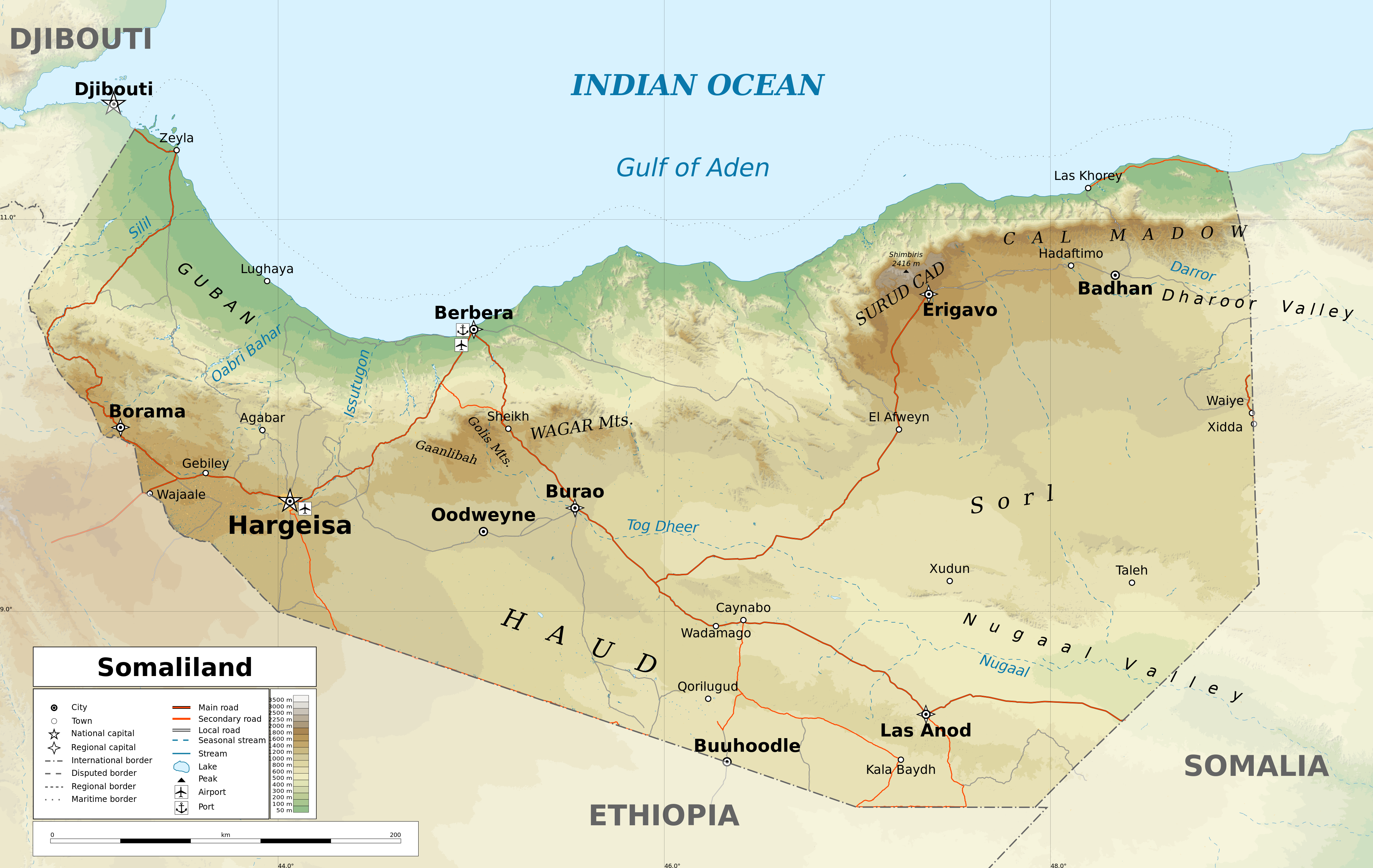
English: Geographic map of Somaliland. Geographic limits of the map:
|
| දිනය | |
| මූලාශ්රය |
ස්වයං නිර්මාණයකි
|
| කර්තෘ | Ikonact |
| අවසරය (මෙම ගොනුව නැවත භාවිතා කරමින්) |
Any use of this map is subject of the license(s) stated below with the condition that you credit (Wikimedia Commons user: Ikonact) as the author . A message with a reply address would also be greatly appreciated. |
| අනෙකුත් අනුවාදයන් |
[]
|
| SVG genesis |


Assessment
|
බලපත්රීකරණය
මෙම කෘතියෙහි හිමිකම් අයිතීන් දරන්නා වන මම,පහත වරපත යටතේ එය ප්රකාශයට පත් කරමි:
This file is licensed under the Creative Commons Attribution-Share Alike 4.0 International license.
- ඔබ නිදහස්:
- බෙදාහදා ගැනීමට – කාර්යය පිටපත් කිරීමට,බෙදා හැරීමට සහ සම්ප්රේෂණය කිරීමට
- නැවත සංකලනය කිරීමට – කාර්යයට අනුවර්තනය වීමට
- පහත කොන්දේසිවලට යටත්ව:
- attribution – වරපත වෙත බැඳියක්ද සපයමින් ඔබ විසින් සුදුසු කර්තෘභාරය ප්රදානය කල යුතු අතර, කිසියම් වෙනස්වීම් සිදුකලේ නම් එයද සඳහන් කල යුතු වෙයි. ඕනෑම සුදුසු ආකාරයට මෙය ඔබ විසින් සිදුකල හැකි මුත්, වරපත්දායකයා විසින් ඔබ හෝ ඔබගේ භාවිතය හෝ පිටසන් කරන බවට ඇඟවෙන ලෙසින් එය සිදු නොකල යුතු වෙයි.
- share alike – මෙම විෂය කාරණා භාවිතා කොට නැවත සංකලනය, ප්රතියෝජනය හෝ වැඩිදියුණුව කලේ නම්, ඉන්පසු ඔබගේ දායකත්වය ඔබ විසින් බෙදාහැරිය යුත්තේ මුල් වරපත හා සමාන හෝ සංගතික හෝ වරපතක් භාවිතා කරමිනි.
ගොනු ඉතිහාසය
එම අවස්ථාවෙහිදී ගොනුව පැවැති ආකාරය නැරඹීමට දිනය/වේලාව මත ක්ලික් කරන්න.
| දිනය/වේලාව | කුඩා-රූපය | මාන | පරිශීලක | පරිකථනය | |
|---|---|---|---|---|---|
| වත්මන් | 17:20, 13 පෙබරවාරි 2022 | | 4,110 × 2,600 (11.09 මෙ.බ.) | Jacob300 | Reverted to version as of 22:29, 26 August 2021 (UTC) |
| 08:01, 27 අගෝස්තු 2021 |  | 4,110 × 2,600 (11.27 මෙ.බ.) | Ikonact | Reverted to version as of 11:59, 26 August 2021 (UTC) - the eastern border is disputed and should stay as such | |
| 22:29, 26 අගෝස්තු 2021 |  | 4,110 × 2,600 (11.09 මෙ.බ.) | Siirski | Corrected eastern border | |
| 11:59, 26 අගෝස්තු 2021 |  | 4,110 × 2,600 (11.27 මෙ.බ.) | Ikonact | final touch | |
| 09:37, 26 අගෝස්තු 2021 |  | 4,110 × 2,600 (11.36 මෙ.බ.) | Ikonact | legend, names in En | |
| 20:47, 25 අගෝස්තු 2021 |  | 4,110 × 2,600 (11.33 මෙ.බ.) | Ikonact | + mnts nammes | |
| 20:07, 25 අගෝස්තු 2021 |  | 4,110 × 2,600 (11.32 මෙ.බ.) | Ikonact | font | |
| 20:03, 25 අගෝස්තු 2021 |  | 4,110 × 2,600 (11.32 මෙ.බ.) | Ikonact | more data | |
| 12:56, 24 අගෝස්තු 2021 |  | 4,110 × 2,600 (16.17 මෙ.බ.) | Ikonact | == {{int:filedesc}} == {{Information |description={{en|Geographic map of {{W|Somaliland}}. Geographic limits of the map:}} *N: 12.12° N *S: 7.69° N *W: 42.56° E *E: 49.67° E Equidistant Cylindrical projection; WGS 84 datum |date=2021-08-24 |source={{own}} *Sources of data:<br/> **Topography: SRTM3 v4 (public domain);<br/> **Rivers and water bodies: Natural Earth, © OpenStreetMap contributors **Borders and towns: © OpenStreetMap contributors;<br/> *Tool:<br/> **The map is created with Octave s... |
ගොනු භාවිතය
පහත දැක්වෙන පිටු 2 ක් විසින් මෙම ගොනුව භාවිතා කෙරෙයි:
ගෝලීය ගොනු භාවිතය
පහත දැක්වෙන අනෙකුත් විකියන් මගින් මෙම ගොනුව භාවිතා කරයි:
- ar.wikipedia.org හි භාවිතය
- bg.wikipedia.org හි භාවිතය
- ca.wikipedia.org හි භාවිතය
- da.wikipedia.org හි භාවිතය
- de.wikipedia.org හි භාවිතය
- en.wikipedia.org හි භාවිතය
- fr.wikipedia.org හි භාවිතය
- ga.wikipedia.org හි භාවිතය
- gl.wikipedia.org හි භාවිතය
- hu.wikipedia.org හි භාවිතය
- id.wikipedia.org හි භාවිතය
- is.wikipedia.org හි භාවිතය
- ja.wikipedia.org හි භාවිතය
- ku.wikipedia.org හි භාවිතය
- lt.wikipedia.org හි භාවිතය
- ru.wikivoyage.org හි භාවිතය
- sh.wikipedia.org හි භාවිතය
- so.wikipedia.org හි භාවිතය
- sv.wikipedia.org හි භාවිතය
- tt.wikipedia.org හි භාවිතය
- www.wikidata.org හි භාවිතය
- zh.wikipedia.org හි භාවිතය