ගොනුව:ElectoralCollege1789.svg

Size of this PNG preview of this SVG file: 542 × 446 පික්සල. අනෙකුත් විභේදනයන්: 292 × 240 පික්සල | 583 × 480 පික්සල | 933 × 768 පික්සල | 1,245 × 1,024 පික්සල | 2,489 × 2,048 පික්සල.
මුල් ගොනුව (SVG ගොනුව, නාමමාත්රිකව 542 × 446 පික්සල්, ගොනු විශාලත්වය: 49 කි.බ.)
| U.S. presidential election maps (SVG) |
| See also: National Atlas maps (png) |
|
1789 · 1792 · 1796 · 1800 · 1804 · 1808 · 1812 · 1816 · 1820 · 1824 · 1828 · 1832 · 1836 · 1840 · 1844 · 1848 · 1852 · 1856 · 1860 · 1864 · 1868 · 1872 · 1876 · 1880 · 1884 · 1888 · 1892 · 1896 · 1900 · 1904 · 1908 · 1912 · 1916 · 1920 · 1924 · 1928 · 1932 · 1936 · 1940 · 1944 · 1948 · 1952 · 1956 · 1960 · 1964 · 1968 · 1972 · 1976 · 1980 · 1984 · 1988 · 1992 · 1996 · 2000 · 2004 · 2008 · 2012 · 2016 · 2020 · 2024 |
සාරාංශය
| විස්තරය |
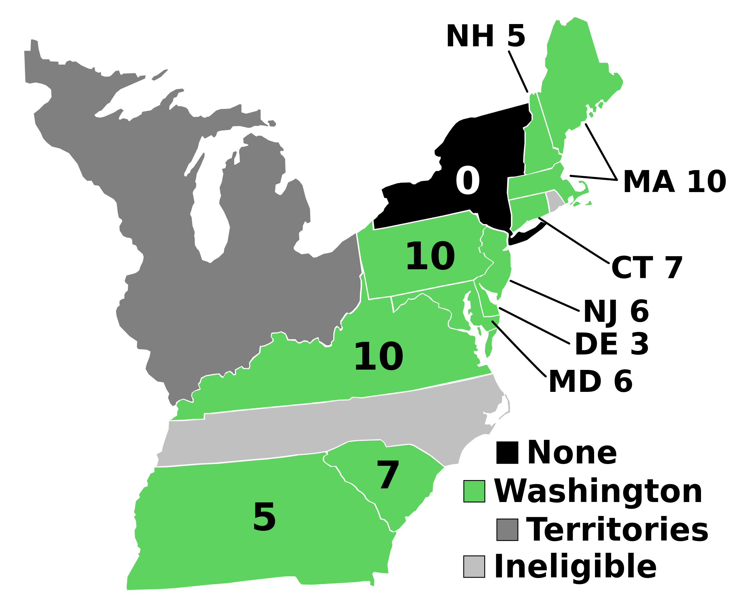
English: Electoral votes by state.
Note: North Carolina and Rhode Island had not yet ratified the Constitution so were therefore ineligible to choose electors. The New York legislature was deadlocked so therefore no electors were chosen. Vermont had been acting independently, but was still considered part of New York at the time. עברית: חלוקת האלקטורים לפי מדינה. |
| මූලාශ්රය | ස්වයං නිර්මාණයකි |
| කර්තෘ | AndyHogan14 |
| අනෙකුත් අනුවාදයන් |
Derivative works of this file: |
| SVG development | W3C-validity not checked. |
බලපත්රීකරණය
| මම, මෙම කාර්යයේ ප්රතිරූපණ අයිති හිමිකරු, මෙම කාර්යය public domain වෙත නිදහස් කරමි. මෙය ලෝක ව්යාප්තව අදාළ වේ. සමහර රටවල මෙය අනීතික විය හැකිය. එසේ වුවහොත්; මම කිසිදු කොන්දේසියකින් තොරව,ඕනෑම අයෙකුට ඕනෑම කාර්යයක් සඳහා මෙය, නීතිමය බාධාවක් නොමැති වනතුරු, භාවිතා කිරීමේ අයිතිය ලබාදෙමි. |
ගොනු ඉතිහාසය
එම අවස්ථාවෙහිදී ගොනුව පැවැති ආකාරය නැරඹීමට දිනය/වේලාව මත ක්ලික් කරන්න.
| දිනය/වේලාව | කුඩා-රූපය | මාන | පරිශීලක | පරිකථනය | |
|---|---|---|---|---|---|
| වත්මන් | 17:02, 2 සැප්තැම්බර් 2023 | | 542 × 446 (49 කි.බ.) | Clarinetguy097 | This should fix the issue with text being cut off. |
| 16:49, 2 සැප්තැම්බර් 2023 |  | 542 × 446 (49 කි.බ.) | Clarinetguy097 | I'd instead argue that North Carolina and Rhode Island didn't stop being part of the US when the Constitution went into effect. | |
| 04:40, 29 ඔක්තෝබර් 2021 |  | 542 × 446 (38 කි.බ.) | Fluffy89502 | NC & RI were not a part of the United States | |
| 04:46, 23 මැයි 2020 |  | 542 × 446 (40 කි.බ.) | Spellcheck | Recreated based on 1800 map for consistency Also added legend entry for ineligible states | |
| 06:46, 14 නොවැම්බර් 2016 |  | 535 × 437 (35 කි.බ.) | Wow | New York and font | |
| 04:38, 22 මැයි 2010 |  | 535 × 437 (29 කි.බ.) | Ibagli | No DC in 1789 | |
| 19:38, 31 දෙසැම්බර් 2008 |  | 535 × 437 (28 කි.බ.) | AndyHogan14 | {{Information |Description= |Source=self-made |Date= |Author= AndyHogan14 |Permission= |other_versions= }} |
ගොනු භාවිතය
පහත දැක්වෙන පිටුව විසින් මෙම ගොනුව භාවිතා කෙරෙයි:
ගෝලීය ගොනු භාවිතය
පහත දැක්වෙන අනෙකුත් විකියන් මගින් මෙම ගොනුව භාවිතා කරයි:
- ca.wikipedia.org හි භාවිතය
- cs.wikipedia.org හි භාවිතය
- da.wikipedia.org හි භාවිතය
- de.wikipedia.org හි භාවිතය
- el.wikipedia.org හි භාවිතය
- en.wikipedia.org හි භාවිතය
- 1788–89 United States presidential election
- List of United States presidential election results by state
- United States presidential election
- 1788–89 United States presidential election in Pennsylvania
- 1788–89 United States elections
- 1788–89 United States presidential election in Connecticut
- 1788–89 United States presidential election in Massachusetts
- 1788–89 United States presidential election in New Hampshire
- 1788–89 United States presidential election in New Jersey
- 1788–89 United States presidential election in South Carolina
- 1788–89 United States presidential election in Delaware
- 1788–89 United States presidential election in Georgia
- 1788–89 United States presidential election in Maryland
- 1788–89 United States presidential election in Virginia
- User:Speedicus/sandbox
- Template:State results of the 1788–89 U.S. presidential election
- Electoral history of John Adams
- es.wikipedia.org හි භාවිතය
- fi.wikipedia.org හි භාවිතය
- fr.wikipedia.org හි භාවිතය
- he.wikipedia.org හි භාවිතය
- it.wikipedia.org හි භාවිතය
- ja.wikipedia.org හි භාවිතය
- ko.wikipedia.org හි භාවිතය
- lt.wikipedia.org හි භාවිතය
- lv.wikipedia.org හි භාවිතය
- mk.wikipedia.org හි භාවිතය
- nl.wikipedia.org හි භාවිතය
- pl.wikipedia.org හි භාවිතය
- ru.wikipedia.org හි භාවිතය
- simple.wikipedia.org හි භාවිතය
- sr.wikipedia.org හි භාවිතය
- sv.wikipedia.org හි භාවිතය
- tr.wikipedia.org හි භාවිතය
- vi.wikipedia.org හි භාවිතය
- www.wikidata.org හි භාවිතය
- zh.wikipedia.org හි භාවිතය