ගොනුව:County Down UK location map.svg

මුල් ගොනුව (SVG ගොනුව, නාමමාත්රිකව 742 × 812 පික්සල්, ගොනු විශාලත්වය: 1.73 මෙ.බ.)
| විස්තරය |
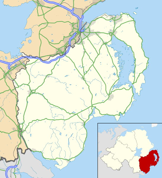
Map of County Down, UK with the following information shown:
Geographic limits:
|
|||
| දිනය | ||||
| මූලාශ්රය |
Ordnance Survey of Northern Ireland OpenData
Ordnance Survey OpenData
|
|||
| කර්තෘ | Nilfanion, created using OSNI data | |||
| අවසරය (මෙම ගොනුව නැවත භාවිතා කරමින්) |
මෙම ගොනුව ක්රියේටිව් කොමන්ස් Attribution-Share Alike 3.0 Unported වරපත යටතේ අවසර ලබා ඇත. Attribution: Contains LPS Intellectual Property and Ordnance Survey data © Crown copyright and database right 2016
|
ගොනු ඉතිහාසය
එම අවස්ථාවෙහිදී ගොනුව පැවැති ආකාරය නැරඹීමට දිනය/වේලාව මත ක්ලික් කරන්න.
| දිනය/වේලාව | කුඩා-රූපය | මාන | පරිශීලක | පරිකථනය | |
|---|---|---|---|---|---|
| වත්මන් | 12:45, 15 මැයි 2016 | | 742 × 812 (1.73 මෙ.බ.) | Nilfanion | {{Information |Description=Map of County Down, UK with the following information shown: *Administrative borders *Coastline, lakes and rivers *Roads and railways *Urban areas Equirectangular map projection on WGS 84 datum, with N/S s... |
ගොනු භාවිතය
පහත දැක්වෙන පිටු 3 ක් විසින් මෙම ගොනුව භාවිතා කෙරෙයි:
ගෝලීය ගොනු භාවිතය
පහත දැක්වෙන අනෙකුත් විකියන් මගින් මෙම ගොනුව භාවිතා කරයි:
- en.wikipedia.org හි භාවිතය
- Downpatrick
- Newcastle, County Down
- Newtownards
- List of monastic houses in Ireland
- Bangor, County Down
- Dundrum, County Down
- Ardglass
- Donaghadee
- Warrenpoint
- Rostrevor
- Portaferry
- Kilkeel
- Killyleagh
- Comber
- Copeland Islands
- Royal Hillsborough
- Kircubbin, County Down
- Burr Point
- Carryduff
- Holywood, County Down
- Ballynahinch, County Down
- Crossgar
- Castlewellan
- Saintfield
- Annalong
- Slieve Donard
- Silent Valley Reservoir
- Magheralin
- Dromore, County Down
- Mayobridge
- Mazetown
- Hilltown, County Down
- Bangor Abbey
- Lurganare
- Millisle
- Ulster Folk and Transport Museums
- Dundonald, County Down
- Groomsport
- Ballela
- Kinallen
- Portavogie
- Bleary
- Gilford, County Down
- Loughinisland
- Strangford
- Páirc Esler
- Ballynoe, County Down
- Helen's Bay
- Rathfriland
- Cultra
මෙම ගොනුවේ තවත් ගෝලීය භාවිත බලන්න.