ගොනුව:Bedfordshire UK location map.svg

Size of this PNG preview of this SVG file: 530 × 599 පික්සල. අනෙකුත් විභේදනයන්: 212 × 240 පික්සල | 425 × 480 පික්සල | 679 × 768 පික්සල | 906 × 1,024 පික්සල | 1,812 × 2,048 පික්සල | 1,120 × 1,266 පික්සල.
මුල් ගොනුව (SVG ගොනුව, නාමමාත්රිකව 1,120 × 1,266 පික්සල්, ගොනු විශාලත්වය: 1.34 මෙ.බ.)
| විස්තරය |
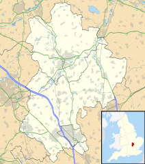
Map of Bedfordshire, UK with the following information shown:
Equirectangular map projection on WGS 84 datum, with N/S stretched 160% Geographic limits:
|
| දිනය | |
| මූලාශ්රය |
|
| කර්තෘ | Nilfanion, created using Ordnance Survey data |
| අවසරය (මෙම ගොනුව නැවත භාවිතා කරමින්) |
මෙම ගොනුව ක්රියේටිව් කොමන්ස් Attribution-Share Alike 3.0 Unported වරපත යටතේ අවසර ලබා ඇත. Attribution: Contains Ordnance Survey data © Crown copyright and database right
|
| අනෙකුත් අනුවාදයන් | File:Bedfordshire UK district map (blank).svg - Blank map with administrative borders only. |
.svg)
ගොනු ඉතිහාසය
එම අවස්ථාවෙහිදී ගොනුව පැවැති ආකාරය නැරඹීමට දිනය/වේලාව මත ක්ලික් කරන්න.
| දිනය/වේලාව | කුඩා-රූපය | මාන | පරිශීලක | පරිකථනය | |
|---|---|---|---|---|---|
| වත්මන් | 17:56, 26 සැප්තැම්බර් 2010 | | 1,120 × 1,266 (1.34 මෙ.බ.) | Nilfanion | Tweak m-ways .. again.. |
| 23:56, 6 සැප්තැම්බර් 2010 |  | 1,120 × 1,266 (1.34 මෙ.බ.) | Nilfanion | Tweaking urban areas, road colours and boundary lines | |
| 20:36, 4 සැප්තැම්බර් 2010 |  | 1,120 × 1,266 (1.29 මෙ.බ.) | Nilfanion | {{Information |Description=Map of Bedfordshire, UK with the following information shown: *Administrative borders *Coastline, lakes and rivers *Motorways, primary routes and A-roads *Urban areas Equirectangular map projection on WGS 84 |
ගොනු භාවිතය
පහත දැක්වෙන පිටු 3 ක් විසින් මෙම ගොනුව භාවිතා කෙරෙයි:
ගෝලීය ගොනු භාවිතය
පහත දැක්වෙන අනෙකුත් විකියන් මගින් මෙම ගොනුව භාවිතා කරයි:
- af.wikipedia.org හි භාවිතය
- ar.wikipedia.org හි භාවිතය
- bg.wikipedia.org හි භාවිතය
- bn.wikipedia.org හි භාවිතය
- ceb.wikipedia.org හි භාවිතය
- en.wikipedia.org හි භාවිතය
- Bedford
- Bushmead Priory
- Beeston, Bedfordshire
- Luton Airport
- Flitwick
- Kempston
- Biggleswade
- Sandy, Bedfordshire
- Little Barford
- Ampthill
- Leighton Buzzard
- Woburn, Bedfordshire
- Eaton Bray
- Linslade
- Southcote, Bedfordshire
- Woburn Sands
- Studham
- Potton
- Old Warden
- Billington, Bedfordshire
- Eversholt
- RAF Chicksands
- RAF Henlow
- Bromham, Bedfordshire
- Everton, Bedfordshire
- List of places in Bedfordshire
- Stagsden
- Clapham, Bedfordshire
- Pertenhall
- RAE Bedford
- Hockliffe
- Houghton House
- Luton Hoo
- Campton, Bedfordshire
- Haynes, Bedfordshire
- Civil parishes in Bedfordshire
- Wootton, Bedfordshire
- Cranfield
- Hundred of Biggleswade
- Cockayne Hatley
- Odell, Bedfordshire
- Wrest Park
- Cardington, Bedfordshire
මෙම ගොනුවේ තවත් ගෝලීය භාවිත බලන්න.