ගොනුව:Australia.A2002231.0145.250m NASA Nullarbor.jpg

මුල් ගොනුව (5,800 × 4,400 පික්සල, ගොනු විශාලත්වය: 2.91 මෙ.බ., MIME ශෛලිය: image/jpeg)
සාරාංශය
- Credit Jacques Descloitres, MODIS Rapid Response Team, NASA/GSFC
http://visibleearth.nasa.gov/view_rec.php?id=4153 archive copy at the Wayback Machine
Metadata Sensor Terra/MODIS Datastart 2002-08-19 Dataend 2002-08-19 Visible Earth v1 ID 21116 Visualization Date 2002-09-16
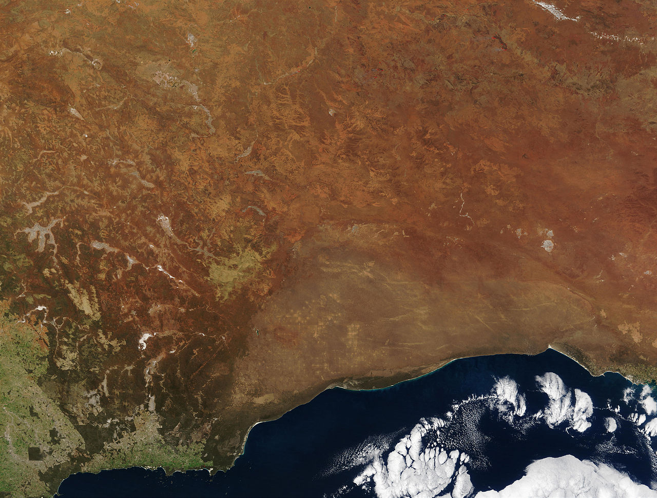
"The striking orange-red colored southern Australian coast contrasts against the deep sapphire-blue waters of the Southern Ocean in this true-color Moderate Resolution Imaging Spectroradiometer (MODIS) image acquired by the Terra satellite on August 19, 2002. In the northern portion of the image, a handful of fires (marked in red) were detected burning in the Great Victoria Desert by the MODIS instrument. South of the desert is the lighter-orange Nullarbor Plain, which stretches for over 1000 kilometers (about 600 miles) from end to end. Finally, just off the coast in the Southern Ocean is the Great Australian Bight, home to Australian Sea Lions, Southern Right Whales, and various fish species."
| This file is in the public domain in the United States because it was solely created by NASA. NASA copyright policy states that "NASA material is not protected by copyright unless noted". (See Template:PD-USGov, NASA copyright policy page or JPL Image Use Policy.) | ||
 |
Warnings:
|
en:Image:Australia.A2002231.0145.250m_NASA_Nullarbor.jpg
බලපත්රීකරණය
| මෙම ගොනුව ක්රියේටිව් කොමන්ස් Attribution-Share Alike 3.0 Unported වරපත යටතේ අවසර ලබා ඇත. Subject to disclaimers. | ||
| ||
| GFDL බලපත්ර යාවත්කාල කෙරුමහි කොටසක් ලෙස මෙම ගොනුවට බලපත්ර ටැගය එක් කෙරිනි. |

|
Free Software Foundation විසින් ප්රකාශිත GNU Free Documentation License බලපත්රයෙහි 1.2 හෝ ඊට අලුත් පිටපත්වල කොන්දේසිවලට යටත්ව මෙම ගොනුව පිටපත් කෙරුමට, නැවත බෙදාහාරුමට සහ/හෝ වෙනස් කෙරුමට අවසර දී ඇත; ඒ වෙනස් අංශ නොමැතිව, මුල් පිටු පෙළ නොමැතිව, පසු පිටු පෙළ නොමැතිවය. බලපත්රයේ පිටපතක් GNU Free Documentation License නම් අංශයේ දැක්වේ. Subject to disclaimers. |
ගොනු ඉතිහාසය
එම අවස්ථාවෙහිදී ගොනුව පැවැති ආකාරය නැරඹීමට දිනය/වේලාව මත ක්ලික් කරන්න.
| දිනය/වේලාව | කුඩා-රූපය | මාන | පරිශීලක | පරිකථනය | |
|---|---|---|---|---|---|
| වත්මන් | 20:27, 24 ඔක්තෝබර් 2005 | | 5,800 × 4,400 (2.91 මෙ.බ.) | Albinfo | *Credit Jacques Descloitres, MODIS Rapid Response Team, NASA/GSFC http://visibleearth.nasa.gov/view_rec.php?id=4153 Metadata Sensor Terra/MODIS Datastart 2002-08-19 Dataend 2002-08-19 Visible Earth v1 ID 21116 Visualization Date 2002-09-16 "The |
ගොනු භාවිතය
පහත දැක්වෙන පිටුව විසින් මෙම ගොනුව භාවිතා කෙරෙයි:
ගෝලීය ගොනු භාවිතය
පහත දැක්වෙන අනෙකුත් විකියන් මගින් මෙම ගොනුව භාවිතා කරයි:
- af.wikipedia.org හි භාවිතය
- an.wikipedia.org හි භාවිතය
- ar.wikipedia.org හි භාවිතය
- arz.wikipedia.org හි භාවිතය
- ast.wikipedia.org හි භාවිතය
- avk.wikipedia.org හි භාවිතය
- az.wikipedia.org හි භාවිතය
- ba.wikipedia.org හි භාවිතය
- be-tarask.wikipedia.org හි භාවිතය
- be.wikipedia.org හි භාවිතය
- bg.wikipedia.org හි භාවිතය
- bn.wikipedia.org හි භාවිතය
- ca.wikipedia.org හි භාවිතය
- ceb.wikipedia.org හි භාවිතය
- cy.wikipedia.org හි භාවිතය
- da.wikipedia.org හි භාවිතය
- de.wikipedia.org හි භාවිතය
- en.wikipedia.org හි භාවිතය
- en.wikiversity.org හි භාවිතය
- en.wikivoyage.org හි භාවිතය
- eo.wikipedia.org හි භාවිතය
- es.wikipedia.org හි භාවිතය
- es.wikivoyage.org හි භාවිතය
- eu.wikipedia.org හි භාවිතය
- fa.wikipedia.org හි භාවිතය
- fi.wikipedia.org හි භාවිතය
- frr.wikipedia.org හි භාවිතය
මෙම ගොනුවේ තවත් ගෝලීය භාවිත බලන්න.