ගොනුව:Alaska climate regions USGS.gif
මෙයට ඉහල විසර්ජනයක් ලබාගත නොහැක.
Alaska_climate_regions_USGS.gif (418 × 351 පික්සල, ගොනු විශාලත්වය: 17 කි.බ., MIME ශෛලිය: image/gif)
සාරාංශය
| විස්තරය |
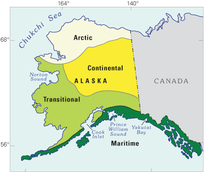
English: Schematic map showing a classification of modern-day climate zones in Alaska. This map is from a USGS website:Latest Wisconsin Deglaciation and Postglacial Vegetation Development in the Turnagain Arm Area, Upper Cook Inlet, South-Central Alaska |
| දිනය | circa 2004; last website update 2010 |
| මූලාශ්රය | http://esp.cr.usgs.gov/research/alaska/turnarm.html |
| කර්තෘ | Thomas A. Ager and Paul E. Carrara, USGS |
බලපත්රීකරණය
This work is in the public domain in the United States because it is a work prepared by an officer or employee of the United States Government as part of that person’s official duties under the terms of Title 17, Chapter 1, Section 105 of the US Code.
Note: This only applies to original works of the Federal Government and not to the work of any individual U.S. state, territory, commonwealth, county, municipality, or any other subdivision. This template also does not apply to postage stamp designs published by the United States Postal Service since 1978. (See § 313.6(C)(1) of Compendium of U.S. Copyright Office Practices). It also does not apply to certain US coins; see The US Mint Terms of Use.
|
 | |
| මෙම ගොනුව ප්රතිරූපණ හිමිකම් අයිතියෙන්, වෙනත් සියළුම ආශ්රිත හෝ ආසන්න අයිතියන් ඇතුළුව, දන්නා සියළු සීමා කිරීම්වලින් නිදහස් බව හඳුනාගෙන ඇත. | ||
ගොනු ඉතිහාසය
එම අවස්ථාවෙහිදී ගොනුව පැවැති ආකාරය නැරඹීමට දිනය/වේලාව මත ක්ලික් කරන්න.
| දිනය/වේලාව | කුඩා-රූපය | මාන | පරිශීලක | පරිකථනය | |
|---|---|---|---|---|---|
| වත්මන් | 18:34, 28 ජූලි 2012 | | 418 × 351 (17 කි.බ.) | Dankarl | edited out "fig 3" locator box to make figure useful for other applications |
| 15:05, 27 ජූලි 2012 |  | 418 × 351 (17 කි.බ.) | Dankarl |
ගොනු භාවිතය
පහත දැක්වෙන පිටුව විසින් මෙම ගොනුව භාවිතා කෙරෙයි:
ගෝලීය ගොනු භාවිතය
පහත දැක්වෙන අනෙකුත් විකියන් මගින් මෙම ගොනුව භාවිතා කරයි: