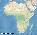
ගොනුව:Africa land cover location map.jpg

මෙම පෙරදසුනෙහි විශාලත්වය: 635 × 600 පික්සල. අනෙකුත් විභේදනයන්: 254 × 240 පික්සල | 508 × 480 පික්සල | 813 × 768 පික්සල | 1,084 × 1,024 පික්සල | 1,525 × 1,440 පික්සල.
මුල් ගොනුව (1,525 × 1,440 පික්සල, ගොනු විශාලත්වය: 523 කි.බ., MIME ශෛලිය: image/jpeg)
ගොනු ඉතිහාසය
එම අවස්ථාවෙහිදී ගොනුව පැවැති ආකාරය නැරඹීමට දිනය/වේලාව මත ක්ලික් කරන්න.
| දිනය/වේලාව | කුඩා-රූපය | මාන | පරිශීලක | පරිකථනය | |
|---|---|---|---|---|---|
| වත්මන් | 18:54, 14 ජූලි 2011 |  | 1,525 × 1,440 (523 කි.බ.) | Sting | Sudan/South Sudan 07-2011 border update |
| 13:33, 19 ජූලි 2010 |  | 1,525 × 1,440 (440 කි.බ.) | Sting | Color profile | |
| 02:55, 7 ජූලි 2010 |  | 1,525 × 1,440 (447 කි.බ.) | Sting | Again... | |
| 02:49, 7 ජූලි 2010 |  | 1,525 × 1,440 (441 කි.බ.) | Sting | Public domain => no copyright mention | |
| 20:29, 3 ජූලි 2010 |  | 1,525 × 1,440 (447 කි.බ.) | Sting | == {{int:filedesc}} == {{Location|00|00|00|N|15|00|00|E|scale:30000000}} <br/>{{Information |Description={{en|Land cover map of Africa simulating the natural aspect of the land with bathymetry; for geo-location purposes.} |
ගොනු භාවිතය
පහත දැක්වෙන පිටු 4 ක් විසින් මෙම ගොනුව භාවිතා කෙරෙයි:
ගෝලීය ගොනු භාවිතය
පහත දැක්වෙන අනෙකුත් විකියන් මගින් මෙම ගොනුව භාවිතා කරයි:
- als.wikipedia.org හි භාවිතය
- ar.wikipedia.org හි භාවිතය
- az.wikipedia.org හි භාවිතය
- ce.wikipedia.org හි භාවිතය
- de.wikipedia.org හි භාවිතය
- en.wikipedia.org හි භාවිතය
- frr.wikipedia.org හි භාවිතය
- fr.wikipedia.org හි භාවිතය
- hr.wikipedia.org හි භාවිතය
- Predložak:Klikabilna mapa start
- Predložak:Etnička karta/BiH/Fojnica
- Predložak:Etnička karta/BiH/Prozor-Rama
- Predložak:Etnička karta/BiH/Uskoplje
- Suradnik:Sombrero/sandbox
- Predložak:Etnička karta/BiH/Konjic
- Predložak:Etnička karta/BiH/Jablanica
- Predložak:Etnička karta/BiH/Kreševo
- Predložak:Etnička karta/BiH/Kupres
- Predložak:Etnička karta/BiH/Bugojno
- Predložak:Etnička karta/BiH/Brčko
- Modul:Location map
- Predložak:Location map
- Modul:Location map/data/Afrika
- Modul:Location map/doc
- Predložak:Location map/doc
- Modul:Location map/data/Afrika/doc
- inh.wikipedia.org හි භාවිතය
- lv.wikipedia.org හි භාවිතය
- myv.wikipedia.org හි භාවිතය
- pt.wikipedia.org හි භාවිතය
- ru.wikipedia.org හි භාවිතය
- uz.wikipedia.org හි භාවිතය
- vi.wikipedia.org හි භාවිතය


