ගොනුව:Adrar Departments2.png
මෙයට ඉහල විසර්ජනයක් ලබාගත නොහැක.
Adrar_Departments2.png (696 × 565 පික්සල, ගොනු විශාලත්වය: 83 කි.බ., MIME ශෛලිය: image/png)
සාරාංශය
| විස්තරය |
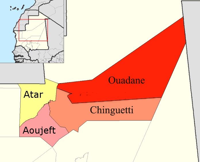
English: Map of the departments of Adrar region of Mauritania. Adapted by User:McTrixie using GIMP, from en:Image:Adrar departments.png created by Rarelibra and from en:Image:Adrar Departments.png by User McTrixie. Summary of changes to original image: two simple enlargements of the names on the map; redone a second time because the names on the map were still small. |
| දිනය | 29 අප්රේල් 2007 (original upload date) |
| මූලාශ්රය | Transferred from en.wikipedia to Commons by Gikü. |
| කර්තෘ | The original uploader was McTrixie at ඉංග්රීසි විකිපීඩියා. |
| අනෙකුත් අනුවාදයන් |
 |
බලපත්රීකරණය

|
Free Software Foundation විසින් ප්රකාශිත GNU Free Documentation License බලපත්රයෙහි 1.2 හෝ ඊට අලුත් පිටපත්වල කොන්දේසිවලට යටත්ව මෙම ගොනුව පිටපත් කෙරුමට, නැවත බෙදාහාරුමට සහ/හෝ වෙනස් කෙරුමට අවසර දී ඇත; ඒ වෙනස් අංශ නොමැතිව, මුල් පිටු පෙළ නොමැතිව, පසු පිටු පෙළ නොමැතිවය. බලපත්රයේ පිටපතක් GNU Free Documentation License නම් අංශයේ දැක්වේ. |
| මෙම ගොනුව ක්රියේටිව් කොමන්ස් Attribution-Share Alike 3.0 Unported වරපත යටතේ අවසර ලබා ඇත. | ||
| ||
| GFDL බලපත්ර යාවත්කාල කෙරුමහි කොටසක් ලෙස මෙම ගොනුවට බලපත්ර ටැගය එක් කෙරිනි. |
ප්රකෘති පැටවුම් ලොගය
The original description page was here. All following user names refer to en.wikipedia.
- 2007-04-29 15:48 McTrixie 776×600× (71024 bytes) Map of the departments of Adrar region of Mauritania. Adapted by User:McTrixie using GIMP, from Image:Adrar departments.png created by Rarelibra. Summary of changes to original image: a simple enlargement of the names on the map, which were so tiny as to
ගොනු ඉතිහාසය
එම අවස්ථාවෙහිදී ගොනුව පැවැති ආකාරය නැරඹීමට දිනය/වේලාව මත ක්ලික් කරන්න.
| දිනය/වේලාව | කුඩා-රූපය | මාන | පරිශීලක | පරිකථනය | |
|---|---|---|---|---|---|
| වත්මන් | 08:49, 19 නොවැම්බර් 2019 | | 696 × 565 (83 කි.බ.) | Clemens Schmillen | Contains all departments of the Adrar Region |
| 12:17, 19 අගෝස්තු 2015 |  | 696 × 565 (47 කි.බ.) | Naturals | colors | |
| 18:48, 15 දෙසැම්බර් 2008 |  | 776 × 600 (69 කි.බ.) | Gikü | {{Information |Description={{en|Map of the departments of Adrar region of Mauritania. Adapted by User:McTrixie using GIMP, from en::Image:Adrar departments.png created by Rarelibra and from en::Image:Adrar Departments.png by User McTrixie. Summa |
ගොනු භාවිතය
පහත දැක්වෙන පිටුව විසින් මෙම ගොනුව භාවිතා කෙරෙයි:
ගෝලීය ගොනු භාවිතය
පහත දැක්වෙන අනෙකුත් විකියන් මගින් මෙම ගොනුව භාවිතා කරයි:
- ar.wikipedia.org හි භාවිතය
- be.wikipedia.org හි භාවිතය
- da.wikipedia.org හි භාවිතය
- de.wikipedia.org හි භාවිතය
- en.wikipedia.org හි භාවිතය
- eo.wikipedia.org හි භාවිතය
- es.wikipedia.org හි භාවිතය
- frr.wikipedia.org හි භාවිතය
- fr.wikipedia.org හි භාවිතය
- it.wikipedia.org හි භාවිතය
- ja.wikipedia.org හි භාවිතය
- lt.wikipedia.org හි භාවිතය
- pt.wikipedia.org හි භාවිතය
- ro.wikipedia.org හි භාවිතය
- ru.wikipedia.org හි භාවිතය
- sv.wikipedia.org හි භාවිතය
- uk.wikipedia.org හි භාවිතය