ගොනුව:Israel location map with stripes.svg

Size of this PNG preview of this SVG file: 322 × 598 පික්සල. අනෙකුත් විභේදනයන්: 129 × 240 පික්සල | 258 × 480 පික්සල | 413 × 768 පික්සල | 551 × 1,024 පික්සල | 1,102 × 2,048 පික්සල | 614 × 1,141 පික්සල.
මුල් ගොනුව (SVG ගොනුව, නාමමාත්රිකව 614 × 1,141 පික්සල්, ගොනු විශාලත්වය: 170 කි.බ.)
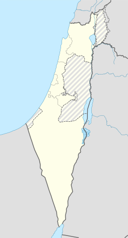
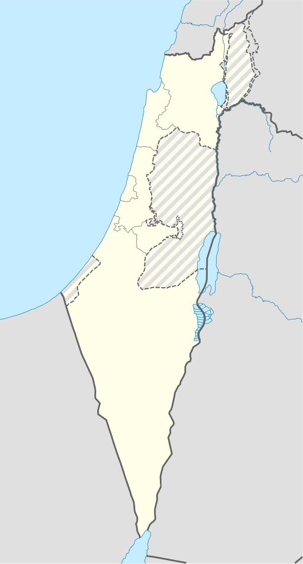
| විස්තරය | Location map of Israel, with the Israeli-occupied Palestinian territories of the West Bank and the Gaza Strip and the Syrian Golan Heights grey stripes. | ||
| දිනය | |||
| මූලාශ්රය | Own work based on: Israel location map.svg by NordNordWest | ||
| කර්තෘ | Jackmcbarn | ||
| අවසරය (මෙම ගොනුව නැවත භාවිතා කරමින්) |
I, මෙම කාර්යයේ ප්රකාශන අයිතිය දරන්නා,පහත බලපත්රය යටතේ එය ප්රකාශයට පත් කරනු ලබයි:
මෙම ගොනුව ක්රියේටිව් කොමන්ස් Attribution-Share Alike 3.0 Unported වරපත යටතේ අවසර ලබා ඇත.
ඔබට අභිමත වරපත තෝරාගත හැක. |
||
| SVG genesis | This locator map was created with unknown tool. |

ගොනු ඉතිහාසය
එම අවස්ථාවෙහිදී ගොනුව පැවැති ආකාරය නැරඹීමට දිනය/වේලාව මත ක්ලික් කරන්න.
| දිනය/වේලාව | කුඩා-රූපය | මාන | පරිශීලක | පරිකථනය | |
|---|---|---|---|---|---|
| වත්මන් | 14:43, 16 ජූනි 2018 | | 614 × 1,141 (170 කි.බ.) | Jdx | Reverted to version as of 10:35, 16 June 2018 (UTC) |
| 14:04, 16 ජූනි 2018 |  | 504 × 936 (170 කි.බ.) | Beebbeebe | Reverted to version as of 00:40, 16 June 2018 (UTC) don't revert without stating a reason | |
| 10:35, 16 ජූනි 2018 |  | 614 × 1,141 (170 කි.බ.) | Denniss | Reverted to version as of 04:28, 21 May 2018 (UTC) | |
| 00:40, 16 ජූනි 2018 |  | 504 × 936 (170 කි.බ.) | Beebbeebe | Reverted to version as of 19:23, 14 May 2018 (UTC) The current map is simply incorrect. And I don't want to upload a new one, I'll have to edit more than a hundred wiki-articles. | |
| 04:28, 21 මැයි 2018 |  | 614 × 1,141 (170 කි.බ.) | Nableezy | Reverted to version as of 19:08, 18 September 2016 (UTC) actually go back to standard no green or blue lines | |
| 18:23, 15 මැයි 2018 |  | 614 × 1,141 (174 කි.බ.) | Nableezy | Reverted to version as of 03:49, 14 May 2018 (UTC) | |
| 19:23, 14 මැයි 2018 |  | 504 × 936 (170 කි.බ.) | Eric's son | Reverted to version as of 13:42, 24 March 2018 (UTC) | |
| 03:49, 14 මැයි 2018 |  | 614 × 1,141 (174 කි.බ.) | Nableezy | Reverted to version as of 06:09, 11 March 2018 (UTC) restore golan as occupied territory | |
| 13:42, 24 මාර්තු 2018 |  | 504 × 936 (170 කි.බ.) | Eric's son | Correcting color for border with Jordan | |
| 13:26, 24 මාර්තු 2018 |  | 504 × 936 (170 කි.බ.) | Eric's son | Fixed correct colors with vector |
ගොනු භාවිතය
පහත දැක්වෙන පිටු 6 ක් විසින් මෙම ගොනුව භාවිතා කෙරෙයි:
ගෝලීය ගොනු භාවිතය
පහත දැක්වෙන අනෙකුත් විකියන් මගින් මෙම ගොනුව භාවිතා කරයි:
- af.wikipedia.org හි භාවිතය
- Rehovot
- Nasaret
- Eilat
- Dimona
- Ramla
- Safed
- Tiberias
- Lod
- Ben Gurion Internasionale Lughawe
- Hadera
- Gedera
- Givatayim
- Be'er Sheva
- Rishon LeZion
- Petah Tikva
- Ashdod
- Netanya
- Binyamina-Giv'at Ada
- Bnei Brak
- Holon
- Ramat Gan
- Ashkelon
- Bat Yam
- Beit Shemesh
- Kfar Saba
- Herzliya
- Modi'in-Maccabim-Re'ut
- Ra'anana
- Ramon-lughawe
- an.wikipedia.org හි භාවිතය
- ar.wikipedia.org හි භාවිතය
- القوات الجوية الإسرائيلية
- قلعة كوكب الهوا
- قالب:Location map Israel Golan
- قالب:Location map Israel ashkelon
- قالب:Location map Israel binyamin
- قالب:Location map Israel center ta
- قالب:Location map Israel haifa
- قالب:Location map Israel jezreel
- قالب:Location map Israel negev mt
- قالب:Location map Israel north haifa
- قالب:Location map Israel north negev
- قالب:Location map Israel northeast
- قالب:Location map Israel northwest
- قالب:Location map Israel northwest negev
- قالب:Location map Israel shomron
- قالب:Location map Israel south wb
- ثقافة كبارية
- مغارة كبارة
මෙම ගොනුවේ තවත් ගෝලීය භාවිත බලන්න.