ගොනුව:Franklingulfstream.jpg
මෙම පෙරදසුනෙහි විශාලත්වය: 736 × 599 පික්සල. අනෙකුත් විභේදනයන්: 295 × 240 පික්සල | 590 × 480 පික්සල | 943 × 768 පික්සල | 1,258 × 1,024 පික්සල | 2,516 × 2,048 පික්සල | 3,089 × 2,515 පික්සල.
මුල් ගොනුව (3,089 × 2,515 පික්සල, ගොනු විශාලත්වය: 1.2 මෙ.බ., MIME ශෛලිය: image/jpeg)
| විස්තරය |
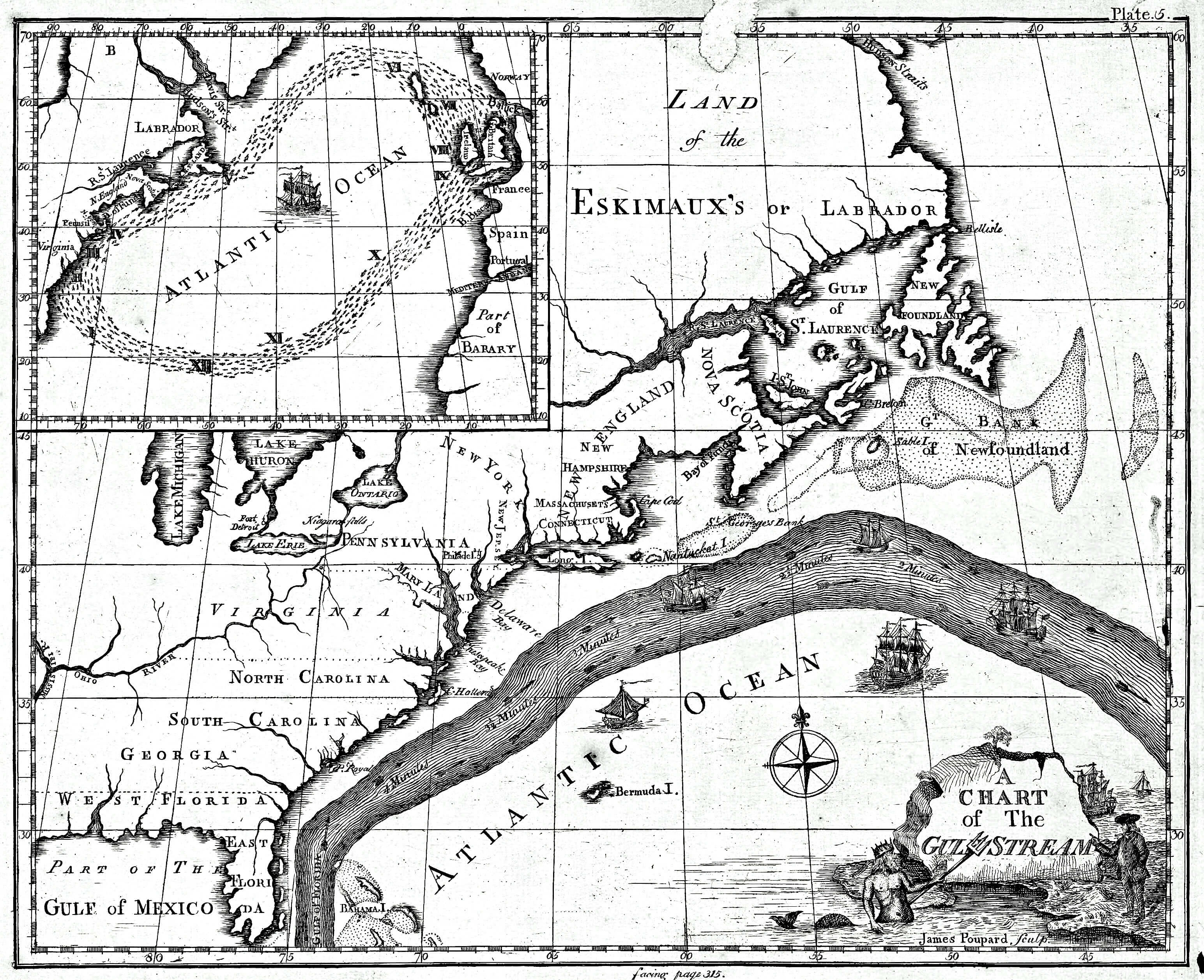
English: Earliest known map of the Gulf Stream |
| දිනය | |
| මූලාශ්රය |
https://www.loc.gov/resource/g9112g.ct000136/ (2018-03-20)
|
| කර්තෘ | Library of Congress/Benjamin Franklin |
| අනෙකුත් අනුවාදයන් |
Cropped version uploaded in September 2016: |
බලපත්රීකරණය
This image is in the public domain because it contains materials that originally came from the U.S. National Oceanic and Atmospheric Administration, taken or made as part of an employee's official duties.
|
ප්රකෘති පැටවුම් ලොගය
The original description page was here. All following user names refer to en.wikipedia.
- 2008-09-21 12:47 Thegreatdr 540×433× (79994 bytes) {{Information |Description=Earliest known map of the Gulf Stream |Source=http://oceanexplorer.noaa.gov/library/readings/hires/gulf_stream_map.jpg |Date=2008-09-21 |Author=Library of Congress/Benjamin Franklin |Permission= |other_versions= }}
ගොනු ඉතිහාසය
එම අවස්ථාවෙහිදී ගොනුව පැවැති ආකාරය නැරඹීමට දිනය/වේලාව මත ක්ලික් කරන්න.
| දිනය/වේලාව | කුඩා-රූපය | මාන | පරිශීලක | පරිකථනය | |
|---|---|---|---|---|---|
| වත්මන් | 17:11, 25 අප්රේල් 2021 | | 3,089 × 2,515 (1.2 මෙ.බ.) | RCraig09 | Version 4: reduced file size at tinyjpg.com |
| 20:32, 20 මාර්තු 2018 |  | 3,089 × 2,515 (2.45 මෙ.බ.) | RCraig09 | Updated version from Library of Congress in response to note on talk page about watermark asserted to be present in earlier uploads. Source (2019-03-20): https://www.loc.gov/resource/g9112g.ct000136/ | |
| 20:39, 26 මාර්තු 2012 |  | 5,868 × 4,761 (5.07 මෙ.බ.) | ServiceAT | Replaced low resolution image by higher resolution scan of same original. | |
| 10:37, 7 ජූලි 2009 |  | 540 × 433 (78 කි.බ.) | Nk | {{Information |Description={{en|Earliest known map of the Gulf Stream}} |Source=Transferred from [http://en.wikipedia.org en.wikipedia]<br/> (Original text : ''http://oceanexplorer.noaa.gov/library/readings/hires/gulf_stream_map.jpg'') |Date={{Date|2008|0 |
ගොනු භාවිතය
පහත දැක්වෙන පිටුව විසින් මෙම ගොනුව භාවිතා කෙරෙයි:
ගෝලීය ගොනු භාවිතය
පහත දැක්වෙන අනෙකුත් විකියන් මගින් මෙම ගොනුව භාවිතා කරයි:
- ast.wikipedia.org හි භාවිතය
- ba.wikipedia.org හි භාවිතය
- bg.wikipedia.org හි භාවිතය
- bs.wikipedia.org හි භාවිතය
- ca.wikipedia.org හි භාවිතය
- en.wikipedia.org හි භාවිතය
- es.wikipedia.org හි භාවිතය
- eu.wikipedia.org හි භාවිතය
- fi.wikipedia.org හි භාවිතය
- fr.wikipedia.org හි භාවිතය
- ha.wikipedia.org හි භාවිතය
- it.wikipedia.org හි භාවිතය
- kn.wikipedia.org හි භාවිතය
- mk.wikipedia.org හි භාවිතය
- ms.wikipedia.org හි භාවිතය
- nn.wikipedia.org හි භාවිතය
- no.wikipedia.org හි භාවිතය
- ru.wikipedia.org හි භාවිතය
- sr.wikipedia.org හි භාවිතය
- tr.wikipedia.org හි භාවිතය
- uk.wikipedia.org හි භාවිතය
- vi.wikipedia.org හි භාවිතය
- zh.wikipedia.org හි භාවිතය