ගොනුව:Detailed Afroasiatic map.svg

Size of this PNG preview of this SVG file: 800 × 503 පික්සල. අනෙකුත් විභේදනයන්: 320 × 201 පික්සල | 640 × 402 පික්සල | 1,024 × 644 පික්සල | 1,280 × 805 පික්සල | 2,560 × 1,609 පික්සල | 1,750 × 1,100 පික්සල.
මුල් ගොනුව (SVG ගොනුව, නාමමාත්රිකව 1,750 × 1,100 පික්සල්, ගොනු විශාලත්වය: 471 කි.බ.)
සාරාංශය
| විස්තරය |
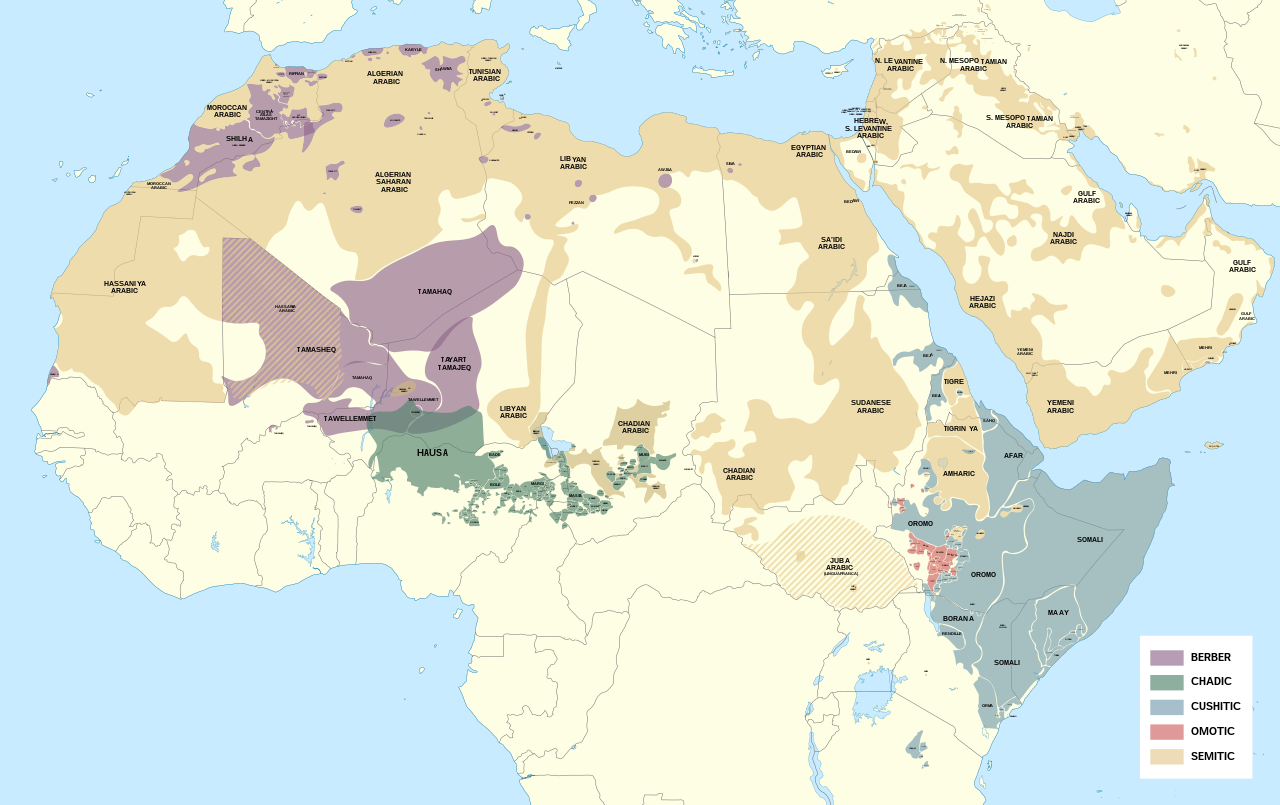
English: Detailed map of Afroasiatic languages in Africa and the Middle East.
This file was derived from: Africa map blank.svg Sources (Wikipedia): External sources:
|
| දිනය | |
| මූලාශ්රය | ස්වයං නිර්මාණයකි |
| කර්තෘ | Noahedits |
![[1]](https://i.pinimg.com/originals/62/b9/94/62b994c3798bc258992de42c46e186fd.png)
![[2]](http://languages.y-bai.com/img/language_map/irq.png)
![[3]](https://i.pinimg.com/564x/8f/52/24/8f522431ee622097dc2550d9ff80480c.jpg)
![[4]](https://i.pinimg.com/originals/d7/88/71/d7887182da05cf42771989eb93960e99.png)
![[5]](https://www.ethnologue.com/sites/default/files/styles/original/public/maps/20/KE_rgb.png?itok=yGwj_XnA)
![[7]](https://www.ethnologue.com/17/sites/default/files/styles/original/public/maps/17/NG_01_rgb/index.png?itok=n1EYvDsI)
![[8]](https://www.ethnologue.com/18/sites/default/files/styles/original/public/maps/18/NG_07_rgb.png?itok=a23BiwQy)
![[9]](https://www.researchgate.net/profile/Adeiza_Isiaka/publication/317208410/figure/fig1/AS:536272059416576@1504868630079/An-index-map-for-some-Nigerian-languages-Ebira-302-is-mainly-spoken-around.png)
![[10]](https://www.researchgate.net/profile/Scott_Maceachern/publication/236160990/figure/fig2/AS:299342981287937@1448380336585/Languages-of-northern-Cameroon-Map-is-the-property-of-SIL-International-and-was-accessed.png)
![[11]](https://asmarttranslatorsreunion.files.wordpress.com/2015/11/om_rgb.png?w=584&h=889)
![[12]](https://1.bp.blogspot.com/-BeNgqhpZtGo/U3LO9MGkfOI/AAAAAAAAIqw/C4np8aWpWdQ/s1600/YE_rgb.png)
![[14]](https://i.pinimg.com/originals/89/42/66/894266f083206db69405d21bc93811a5.png)
![[16]](https://static.cambridge.org/binary/version/id/urn:cambridge.org:id:binary:20190522054803538-0373:9781108283991:41798map10_1.png?pub-status=live)
බලපත්රීකරණය
මෙම කෘතියෙහි හිමිකම් අයිතීන් දරන්නා වන මම,පහත වරපත යටතේ එය ප්රකාශයට පත් කරමි:
This file is licensed under the Creative Commons Attribution-Share Alike 4.0 International license.
- ඔබ නිදහස්:
- බෙදාහදා ගැනීමට – කාර්යය පිටපත් කිරීමට,බෙදා හැරීමට සහ සම්ප්රේෂණය කිරීමට
- නැවත සංකලනය කිරීමට – කාර්යයට අනුවර්තනය වීමට
- පහත කොන්දේසිවලට යටත්ව:
- attribution – වරපත වෙත බැඳියක්ද සපයමින් ඔබ විසින් සුදුසු කර්තෘභාරය ප්රදානය කල යුතු අතර, කිසියම් වෙනස්වීම් සිදුකලේ නම් එයද සඳහන් කල යුතු වෙයි. ඕනෑම සුදුසු ආකාරයට මෙය ඔබ විසින් සිදුකල හැකි මුත්, වරපත්දායකයා විසින් ඔබ හෝ ඔබගේ භාවිතය හෝ පිටසන් කරන බවට ඇඟවෙන ලෙසින් එය සිදු නොකල යුතු වෙයි.
- share alike – මෙම විෂය කාරණා භාවිතා කොට නැවත සංකලනය, ප්රතියෝජනය හෝ වැඩිදියුණුව කලේ නම්, ඉන්පසු ඔබගේ දායකත්වය ඔබ විසින් බෙදාහැරිය යුත්තේ මුල් වරපත හා සමාන හෝ සංගතික හෝ වරපතක් භාවිතා කරමිනි.
ගොනු ඉතිහාසය
එම අවස්ථාවෙහිදී ගොනුව පැවැති ආකාරය නැරඹීමට දිනය/වේලාව මත ක්ලික් කරන්න.
| දිනය/වේලාව | කුඩා-රූපය | මාන | පරිශීලක | පරිකථනය | |
|---|---|---|---|---|---|
| වත්මන් | 17:35, 13 මැයි 2022 | | 1,750 × 1,100 (471 කි.බ.) | Noahedits | Removing Somaliland (not recognized by the international community) |
| 00:54, 19 ඔක්තෝබර් 2021 |  | 1,750 × 1,100 (549 කි.බ.) | Gebagebo | Added Somaliland | |
| 19:19, 16 මැයි 2020 |  | 1,750 × 1,100 (471 කි.බ.) | Noahedits | Fixed error in Lake Victoria, cleaned up stray lines | |
| 17:33, 23 අප්රේල් 2020 |  | 512 × 322 (484 කි.බ.) | Noahedits | Adjusted location of Borana and Burji | |
| 21:04, 1 අප්රේල් 2020 |  | 512 × 322 (447 කි.බ.) | Noahedits | Detail in central Arabian peninsula | |
| 22:02, 7 පෙබරවාරි 2020 |  | 512 × 325 (491 කි.බ.) | Noahedits | Cleaned up northern Iraq/Syira, fixed misidentification of Beja | |
| 06:06, 7 පෙබරවාරි 2020 |  | 512 × 325 (480 කි.බ.) | Noahedits | Title, legend, slight clean up | |
| 05:41, 7 පෙබරවාරි 2020 |  | 512 × 325 (479 කි.බ.) | Noahedits | User created page with UploadWizard |
ගොනු භාවිතය
පහත දැක්වෙන පිටුව විසින් මෙම ගොනුව භාවිතා කෙරෙයි:
ගෝලීය ගොනු භාවිතය
පහත දැක්වෙන අනෙකුත් විකියන් මගින් මෙම ගොනුව භාවිතා කරයි:
- ar.wikipedia.org හි භාවිතය
- el.wikipedia.org හි භාවිතය
- en.wikipedia.org හි භාවිතය
- es.wikipedia.org හි භාවිතය
- fa.wikipedia.org හි භාවිතය
- fy.wikipedia.org හි භාවිතය
- gl.wikipedia.org හි භාවිතය
- he.wikipedia.org හි භාවිතය
- ie.wikipedia.org හි භාවිතය
- it.wikipedia.org හි භාවිතය
- ja.wikipedia.org හි භාවිතය
- lij.wikipedia.org හි භාවිතය
- mzn.wikipedia.org හි භාවිතය
- ne.wikipedia.org හි භාවිතය
- oc.wikipedia.org හි භාවිතය
- sat.wikipedia.org හි භාවිතය
- simple.wikipedia.org හි භාවිතය
- sr.wikipedia.org හි භාවිතය
- sv.wikipedia.org හි භාවිතය
- tr.wikipedia.org හි භාවිතය