ගොනුව:CarthageMap.png
මෙයට ඉහල විසර්ජනයක් ලබාගත නොහැක.
CarthageMap.png (770 × 447 පික්සල, ගොනු විශාලත්වය: 106 කි.බ., MIME ශෛලිය: image/png)
සාරාංශය
| විස්තරය |
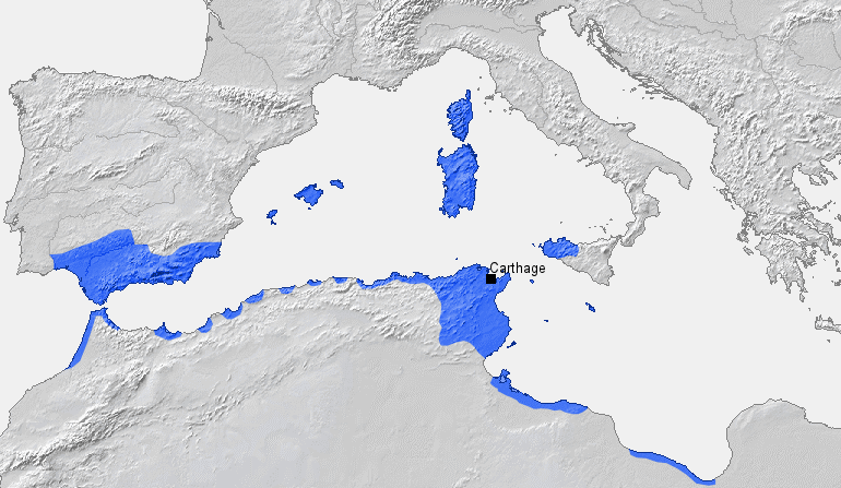
Location of Carthage and Carthaginian sphere of influence prior to the First Punic War (264 BC) Source: Self-made, based on Putzger Atlas und Chronik zur Weltgeschichte, Berlin, 2002 Template: [1] Author: BishkekRocks |
||
| දිනය | 18 මාර්තු 2006 (original upload date) | ||
| මූලාශ්රය | No machine-readable source provided. Own work assumed (based on copyright claims). | ||
| කර්තෘ | No machine-readable author provided. BishkekRocks assumed (based on copyright claims). | ||
| අනෙකුත් අනුවාදයන් |
|

බලපත්රීකරණය
| මම, මෙම කාර්යයේ ප්රතිරූපණ අයිති හිමිකරු, මෙම කාර්යය public domain වෙත නිදහස් කරමි. මෙය ලෝක ව්යාප්තව අදාළ වේ. සමහර රටවල මෙය අනීතික විය හැකිය. එසේ වුවහොත්; මම කිසිදු කොන්දේසියකින් තොරව,ඕනෑම අයෙකුට ඕනෑම කාර්යයක් සඳහා මෙය, නීතිමය බාධාවක් නොමැති වනතුරු, භාවිතා කිරීමේ අයිතිය ලබාදෙමි. |
ගොනු ඉතිහාසය
එම අවස්ථාවෙහිදී ගොනුව පැවැති ආකාරය නැරඹීමට දිනය/වේලාව මත ක්ලික් කරන්න.
| දිනය/වේලාව | කුඩා-රූපය | මාන | පරිශීලක | පරිකථනය | |
|---|---|---|---|---|---|
| වත්මන් | 19:50, 6 අප්රේල් 2023 | | 770 × 447 (106 කි.බ.) | Titanjs | Reverted to version as of 15:31, 18 March 2006 (UTC) |
| 14:16, 23 මාර්තු 2016 |  | 770 × 447 (288 කි.බ.) | Michczu | drobna poprawka | |
| 16:52, 19 සැප්තැම්බර් 2014 |  | 770 × 447 (128 කි.බ.) | Daygum | True areas occupied by chartaginians | |
| 15:31, 18 මාර්තු 2006 |  | 770 × 447 (106 කි.බ.) | BishkekRocks | Location of Carthage and Carthaginian influence sphere before the First Punic War (264 BC) Source: Self-made, based on Putzger Atlas und Chronik zur Weltgeschichte, Berlin, 2002 Template: [http://www.demis.nl/wms/mapclip.htm] Author: ~~~ [[Category:Ca |
ගොනු භාවිතය
පහත දැක්වෙන පිටුව විසින් මෙම ගොනුව භාවිතා කෙරෙයි:
ගෝලීය ගොනු භාවිතය
පහත දැක්වෙන අනෙකුත් විකියන් මගින් මෙම ගොනුව භාවිතා කරයි:
- ar.wikipedia.org හි භාවිතය
- ast.wikipedia.org හි භාවිතය
- azb.wikipedia.org හි භාවිතය
- az.wikipedia.org හි භාවිතය
- ba.wikipedia.org හි භාවිතය
- be-tarask.wikipedia.org හි භාවිතය
- bg.wikipedia.org හි භාවිතය
- bm.wikipedia.org හි භාවිතය
- br.wikipedia.org හි භාවිතය
- bs.wikipedia.org හි භාවිතය
- ca.wikipedia.org හි භාවිතය
- cdo.wikipedia.org හි භාවිතය
- cs.wikipedia.org හි භාවිතය
- de.wikipedia.org හි භාවිතය
- el.wikipedia.org හි භාවිතය
- en.wikipedia.org හි භාවිතය
- eo.wikipedia.org හි භාවිතය
- es.wikipedia.org හි භාවිතය
මෙම ගොනුවේ තවත් ගෝලීය භාවිත බලන්න.