ගොනුව:Algeria pipelines map.jpg
මෙම පෙරදසුනෙහි විශාලත්වය: 624 × 599 පික්සල. අනෙකුත් විභේදනයන්: 250 × 240 පික්සල | 500 × 480 පික්සල | 832 × 799 පික්සල.
මුල් ගොනුව (832 × 799 පික්සල, ගොනු විශාලත්වය: 203 කි.බ., MIME ශෛලිය: image/jpeg)

|
This economic map image could be re-created using vector graphics as an SVG file. This has several advantages; see Commons:Media for cleanup for more information. If an SVG form of this image is available, please upload it and afterwards replace this template with
{{vector version available|new image name}}.
It is recommended to name the SVG file “Algeria pipelines map.svg”—then the template Vector version available (or Vva) does not need the new image name parameter. |


| විස්තරය |
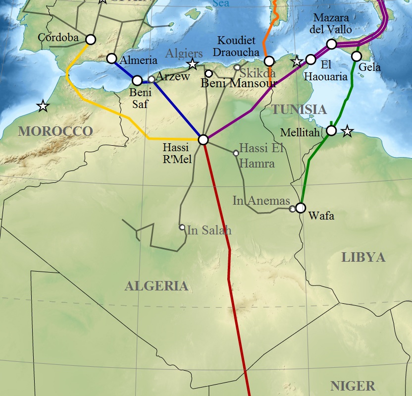
English: Map of gas pipelines across Mediterranee and Sahara : Trans-Saharan, Maghreb–Europe, Medgaz, Galsi, Trans-Mediterranean and Greenstream. Français : Carte des gazoducs traversant le Sahara et la Méditerranée : Trans-saharien, Maghreb–Europe, Gazoduc Medgaz, Galsi, Trans-Méditerranéen et Greenstream. |
| දිනය | (UTC) |
| මූලාශ්රය | |
| කර්තෘ |
|
| This is a retouched picture, which means that it has been digitally altered from its original version. Modifications: Algeria pipelines. The original can be viewed here: Gas pipelines across Mediterranee and Sahara map-en.svg:
|
I, මෙම කාර්යයේ ප්රකාශන අයිතිය දරන්නා,පහත බලපත්රය යටතේ එය ප්රකාශයට පත් කරනු ලබයි:
මෙම ගොනුව Creative Commons Attribution-Share Alike 3.0 Unported, 2.5 Generic, 2.0 Generic සහ 1.0 Generic යටතේ ලියාපදිංචි කර ඇත.
- ඔබ නිදහස්:
- බෙදාහදා ගැනීමට – කාර්යය පිටපත් කිරීමට,බෙදා හැරීමට සහ සම්ප්රේෂණය කිරීමට
- නැවත සංකලනය කිරීමට – කාර්යයට අනුවර්තනය වීමට
- පහත කොන්දේසිවලට යටත්ව:
- attribution – වරපත වෙත බැඳියක්ද සපයමින් ඔබ විසින් සුදුසු කර්තෘභාරය ප්රදානය කල යුතු අතර, කිසියම් වෙනස්වීම් සිදුකලේ නම් එයද සඳහන් කල යුතු වෙයි. ඕනෑම සුදුසු ආකාරයට මෙය ඔබ විසින් සිදුකල හැකි මුත්, වරපත්දායකයා විසින් ඔබ හෝ ඔබගේ භාවිතය හෝ පිටසන් කරන බවට ඇඟවෙන ලෙසින් එය සිදු නොකල යුතු වෙයි.
- share alike – මෙම විෂය කාරණා භාවිතා කොට නැවත සංකලනය, ප්රතියෝජනය හෝ වැඩිදියුණුව කලේ නම්, ඉන්පසු ඔබගේ දායකත්වය ඔබ විසින් බෙදාහැරිය යුත්තේ මුල් වරපත හා සමාන හෝ සංගතික හෝ වරපතක් භාවිතා කරමිනි.

|
Free Software Foundation විසින් ප්රකාශිත GNU Free Documentation License බලපත්රයෙහි 1.2 හෝ ඊට අලුත් පිටපත්වල කොන්දේසිවලට යටත්ව මෙම ගොනුව පිටපත් කෙරුමට, නැවත බෙදාහාරුමට සහ/හෝ වෙනස් කෙරුමට අවසර දී ඇත; ඒ වෙනස් අංශ නොමැතිව, මුල් පිටු පෙළ නොමැතිව, පසු පිටු පෙළ නොමැතිවය. බලපත්රයේ පිටපතක් GNU Free Documentation License නම් අංශයේ දැක්වේ. |
ඔබට අභිමත වරපත තෝරාගත හැක.
ප්රකෘති පැටවුම් ලොගය
This image is a derivative work of the following images:
- File:Gas_pipelines_across_Mediterranee_and_Sahara_map-en.svg licensed with Cc-by-sa-3.0,2.5,2.0,1.0, GFDL
- 2009-07-15T14:34:38Z Sémhur 832x1573 (3945956 Bytes) {{Information |Description= {{en|1=Map of gas pipelines across Mediterranee and Sahara : [[:en:Trans-Saharan gas pipeline|Trans-Saharan]], [[:en:Maghreb–Europe Gas Pipeline|Maghreb–Europe]], [[:en:Medgaz|Medgaz]], [[:en:G
Uploaded with derivativeFX
ගොනු ඉතිහාසය
එම අවස්ථාවෙහිදී ගොනුව පැවැති ආකාරය නැරඹීමට දිනය/වේලාව මත ක්ලික් කරන්න.
| දිනය/වේලාව | කුඩා-රූපය | මාන | පරිශීලක | පරිකථනය | |
|---|---|---|---|---|---|
| වත්මන් | 12:08, 6 මාර්තු 2011 | | 832 × 799 (203 කි.බ.) | Mahmoudb1953 | {{Information |Description={{en|1=Map of gas pipelines across Mediterranee and Sahara : Trans-Saharan, Maghreb–Europe, Medgaz, Galsi, [[:en:Trans-Medit |
ගොනු භාවිතය
පහත දැක්වෙන පිටුව විසින් මෙම ගොනුව භාවිතා කෙරෙයි:
ගෝලීය ගොනු භාවිතය
පහත දැක්වෙන අනෙකුත් විකියන් මගින් මෙම ගොනුව භාවිතා කරයි:
- ar.wikipedia.org හි භාවිතය
- be-tarask.wikipedia.org හි භාවිතය
- be.wikipedia.org හි භාවිතය
- bs.wikipedia.org හි භාවිතය
- ca.wikipedia.org හි භාවිතය
- cy.wikipedia.org හි භාවිතය
- de.wikipedia.org හි භාවිතය
- el.wikipedia.org හි භාවිතය
- en.wikipedia.org හි භාවිතය
- eo.wikipedia.org හි භාවිතය
- es.wikipedia.org හි භාවිතය
- eu.wikipedia.org හි භාවිතය
- fr.wikipedia.org හි භාවිතය
- hu.wikipedia.org හි භාවිතය
- id.wikipedia.org හි භාවිතය
- ja.wikipedia.org හි භාවිතය
- ka.wikipedia.org හි භාවිතය
- lt.wikipedia.org හි භාවිතය
- nl.wikipedia.org හි භාවිතය
- pt.wikipedia.org හි භාවිතය
- ru.wikipedia.org හි භාවිතය
- sl.wikipedia.org හි භාවිතය
- te.wikipedia.org හි භාවිතය
- tum.wikipedia.org හි භාවිතය
- uk.wikipedia.org හි භාවිතය
- uz.wikipedia.org හි භාවිතය
- www.wikidata.org හි භාවිතය