ගොනුව:USGS map of the 2012 Indian Ocean Earthquake.jpg

මෙම පෙරදසුනෙහි විශාලත්වය: 512 × 600 පික්සල. අනෙකුත් විභේදනයන්: 205 × 240 පික්සල | 612 × 717 පික්සල.
මුල් ගොනුව (612 × 717 පික්සල, ගොනු විශාලත්වය: 69 කි.බ., MIME ශෛලිය: image/jpeg)


සාරාංශය
| විස්තරය |
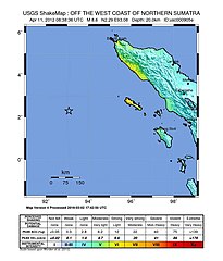
English: Map of the 2012 April 11th earthquake off the coast of Aceh. Mag - 8.6 |
| දිනය | |
| මූලාශ්රය | USGS.gov |
| කර්තෘ | USGS |
බලපත්රීකරණය
This image is in the public domain in the United States because it only contains materials that originally came from the United States Geological Survey, an agency of the United States Department of the Interior. For more information, see the official USGS copyright policy.
|
ගොනු ඉතිහාසය
එම අවස්ථාවෙහිදී ගොනුව පැවැති ආකාරය නැරඹීමට දිනය/වේලාව මත ක්ලික් කරන්න.
| දිනය/වේලාව | කුඩා-රූපය | මාන | පරිශීලක | පරිකථනය | |
|---|---|---|---|---|---|
| වත්මන් | 17:15, 13 මාර්තු 2016 | | 612 × 717 (69 කි.බ.) | Dawnseeker2000 | Newer map that more closely reflects the actual felt intensities of this extraordinarily large strike-slip event. The USGS states that the maximum intensity was VII (''Very strong'') at Banda Aceh and Meulaboh, and VI (''Strong'') at Padang. |
| 12:36, 11 අප්රේල් 2012 |  | 612 × 717 (69 කි.බ.) | YuMaNuMa |
ගොනු භාවිතය
පහත දැක්වෙන පිටුව විසින් මෙම ගොනුව භාවිතා කෙරෙයි:
ගෝලීය ගොනු භාවිතය
පහත දැක්වෙන අනෙකුත් විකියන් මගින් මෙම ගොනුව භාවිතා කරයි:
- ar.wikipedia.org හි භාවිතය
- be.wikipedia.org හි භාවිතය
- de.wikipedia.org හි භාවිතය
- en.wikipedia.org හි භාවිතය
- fi.wikipedia.org හි භාවිතය
- fr.wikipedia.org හි භාවිතය
- id.wikipedia.org හි භාවිතය
- ja.wikipedia.org හි භාවිතය
- ml.wikipedia.org හි භාවිතය
- ms.wikipedia.org හි භාවිතය
- pl.wikipedia.org හි භාවිතය
- pt.wikipedia.org හි භාවිතය
- ru.wikipedia.org හි භාවිතය
- sv.wikipedia.org හි භාවිතය
- tr.wikipedia.org හි භාවිතය
- uk.wikipedia.org හි භාවිතය
- zh.wikipedia.org හි භාවිතය